ADVENTURE HIKES AND CANYONEERING
IN THE SAN GABRIELS
© Christopher Earls Brennen

|
|---|

|
Hike B1. Stone Plus One
- Hiking time (upper drop-in): 7 hours
- Estimated hiking distance: 2.7 miles
- Elevation gain: 1060 feet or 1470 feet
- USGS Topo Maps: Condor Peak
- Difficulties: About eleven rappels, the largest being about 80ft; some bushwhacking
- Special equipment: 200ft rope, 100ft rope, 150ft of webbing, 7 rappel rings, and harnesses.
-
ACA Rating: 3A III

Characteristics
The precipitous north face of Mount Lukens forms the south wall of Big Tujunga and contains a number of rugged canyons. The only problem is that there are few trails which can be used to access these marvellous canyons. The unnamed canyon immediately east of Stone Canyon is a notable exception to this for, during its ascent to the summit of Mount Lukens, the Stone Canyon Trail contours into this neighbour at several points and provides access to this advanced and spectacular adventure. We came to call this canyon Stone Plus One; its descent involves many rappels including one two-stager with a total drop of about 150ft. This monster can be viewed from the Big Tujunga Road, first by locating Stone Plus One by noting the contouring of the Stone Canyon Trail and then locating a point along the road from where you can look up at the middle section of this canyon.
This hike is best for a warm fall day; at that time there is only a small water flow and you can stay quite dry.
Trailhead
Drive up Big Tujunga Road, turn right onto Doske Road and then left on Stonyvale Road. Proceed to the parking lot next to the Wildwood Picnic Area at the end of the road (34o17.67'N 118o14.41'W and elevation 1780ft).
Hike
From the parking area follow the Stone Canyon trail that crosses Mill Creek and then follows the south bank of the river upstream for a short way before turning south at 34o17.55'N 118o14.22'W and climbing up the rise just to east of the Stone Canyon Wash. Hike up the trail as it first climbs the east wall of Stone Canyon and then contours around into the next canyon to the east which we call Stone Plus One. About 30min from the start as the trail contours up the west wall of Stone Plus One you will come to a point at 34o16.97'N 118o14.26'W and an elevation of 2840ft where the trail switches back to the right to climb higher. You will notice a use-trail that proceeds straight on at this switchback. This use-trail contours down toward the canyon bottom. This is the lower of the two possible drop-in points on this hike. I recommend that you take this option on your first adventure in this canyon. While dropping in veer upstream to avoid the steeper slopes. We will resume the description of the hike from the lower drop-in point at the location noted later.
 | 
| |
|---|---|---|
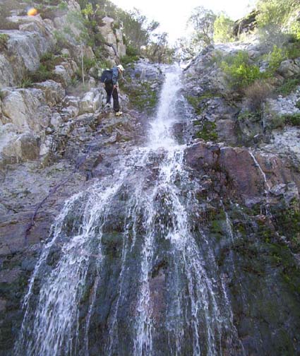
| Large Falls, Upper Section | Large Falls, Lower Section |
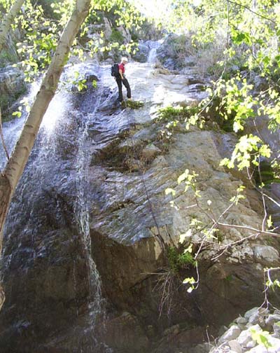
For the upper drop-in proceed on up the main trail to an elevation of about 3260ft. This can be reached about 40min from the trailhead. Just after passing a large conifer the trail rounds a corner and you arrive at another notable viewpoint above Stone Plus One. Here at 34o16.82'N 118o14.38'W there are two drop-in routes close to one another. One route proceeds down the steep rocky ridge below the conifer. The other leaves the trail about 20yds further on and descends a steep gully. Depending on which particular route you follow you may or may not rappel down a 50ft waterfall (the anchor is a tree about 20ft upstream).
All of the upper drop-in routes bring you quickly to the second rappel, a 70ft waterfall with a good tree anchor. The face of this waterfall is quite mucky and so it is best to veer to right during the rappel and head for a large tree that is clearly seen from above. After reaching this tree resume hiking by contouring to the right and descending an earth and scree slope that brings you back to the stream. Just a few more yards and you come to the lip of the next rappel down into a shady glade. This is a nice simple 50ft rappel using the substantial tree off to the right. This is followed almost immediately by a small 15ft rappel using the big tree on left and then a 35ft waterfall that can be downclimbed using the dirt slope on the left.
You have now reached the point of the lower drop-in. Downstream of this there is a wooded section of canyon that ends in a very brushy and bramble-choked stretch. At the end of this stretch is a narrow slot waterfall that is quite awkward not only because of its configuration but also because of the brambles and the lack of an obvious anchor. Instead, we climbed up over the 6ft ridge just upstream of the lip on the right (elevation 2640ft). This leads to a very brushy slope that can be downclimbed to the base of the waterfall, in part by sliding under several bushes. Another unpleasant bush-filled section follows; it is best by-passed on the right and leads to a 30ft waterfall whose lip is covered in brush. However there is a clearing on the right where several big bushes provide good anchors for a 40ft rappel. Another short bush-filled section follows but ends abruptly and, quite unexpectedly, you find yourself at the top of an expansive overlook with a large, vertical drop immediately ahead of you. We reached this viewpoint about 3hrs 15min from the start.
This big drop is the one that you can see most obviously from several vantage points on the Big Tujunga Road. Here at the lip you look down into a large bowl ringed with cliffs of bright sandstone. And you can see the large rock on the shelf about 80ft below that provides the anchor for the second or lower stage of the coming 140ft descent. A large tree just behind the lip provides a reassuringly solid anchor for the 80ft first or upper stage. The rappel is relatively straightforward though I recommend staying as far to the right as you can while going over the lip in order to avoid the water and the slick rock near it. Note the hard granite rock that formed these falls. The 60ft second or lower stage is anchored by the large rock in midstream on the intermediate shelf.
Another short and brushy section of canyon brings you to a rocky chute about 5hrs from the start. This chute can be downclimbed fairly easily. However, you can see from the top that the chute makes a sharp right turn at the bottom. What you cannot see is that this leads immediately to a 35ft, vertical rappel for which there is no easy anchor in the rocky chute. This is the only really serious anchor problem encountered in this canyon. We set three pitons in a crack just above and to the right of the lip of the falls and, as backup, put a length of webbing around a rocky outcropping higher up the chute. The alternative is to climb up to a large bush on the left side and rappel from there. The bottom here is at an elevation of about 2240ft)
A short walk then brings you to the second impressive viewpoint encountered on this hike. Again it is a panoramic view of a large rocky descent. This time, however, the drop consists of five giant steps ranging in height from 10ft to 60ft. The first step requires a 50ft rappel and can be anchored by one or more of the solid bushes on the right. This is followed by two smaller steps that can be downclimbed on the right side. We reached this point 5hr 30min from the trailhead.
The fourth step is the largest and requires a 50ft rappel using as the anchor a large bush on the right with a very large base. The fifth and last step is about 35ft in height. The anchor is a tree about 15ft upstream of the lip on the left. It is almost inevitable that you will have to rappel down through some water here since the entire mossy face is dripping.
As well as the last step this is also the last rappel in this canyon. A few yards downstream, the canyon narrows to a slot through grey rock. The slot turns abruptly right and then 180 degrees back to the left. Fortunately the bottom is relatively flat. Then the bottom broadens into an easy wooded section that presages the end of the canyon. A few hundred yards downstream you may see a ladder on the left that leads to an old mine. And another hundred yards brings you to the canyon exit at 34o17.26'N 118o14.01'W. We reached this point 6hr 40min into the hike.
To get back to the parking area, I recommend turning left
once you reach flat ground and then crossing the flats close
to the mountains to avoid intruding on the private property near
the river. When these flats end, cross Mill Creek
and go north to the
old road close under the northern cliffs. Follow this back to the
parking lot (34o17.67'N 118o14.41'W).
Last updated 4/14/05.
Christopher E. Brennen