ADVENTURE HIKES AND CANYONEERING
IN THE SAN GABRIELS
© Christopher Earls Brennen

|
|---|

|
Hike J2. South Fork of Lytle Creek
- Hiking time: 5 hours
- Estimated hiking distance: 3.7 miles
- Elevation gain: None
- USGS Topo Maps: Cucamonga Peak, Devore
- Difficulties: Three rappels ranging in height up to 80ft and several downclimbs.
- Special equipment: Rapelling equipment with one 200ft rope, 50ft of webbing, 3 rappel rings, harnesses and helmets.
-
ACA Rating: 3A III

Characteristics
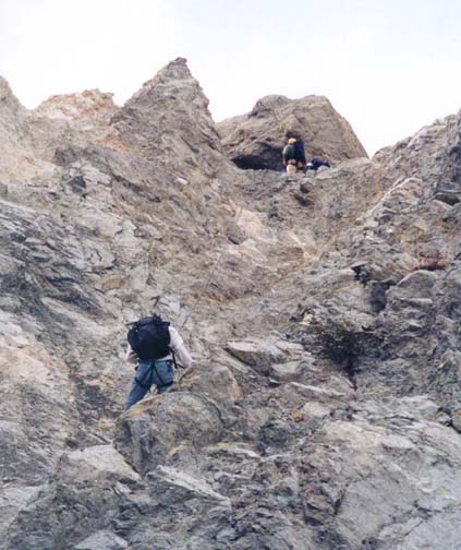
The eastern end of the San Gabriels is riven through by the three forks of Lytle Creek which have created some rugged and beautiful canyons in this section of the mountains. The South Fork of Lytle Creek runs due east from the forested slopes of Cucamonga Peak and then suddenly and precipitously drops down a fractured headwall to a broad, boulder-littered canyon before eventually joining the main Lytle Creek Canyon. This adventure accesses the headwaters of the South Fork of Lytle Creek by means of a 4WD vehicle drive up the rough dirt San Sevaine Flats Road. The hike then travels the entire length of the South Fork, including a three rappel descent of the dramatic headwall. Because of loose rock especially near the headwall, helmets are essential for this hike.
The hike can be completed almost anytime of the year though, in winter you should be prepared for ice at the higher elevations and for frozen waterfalls. It would also be wise to call ahead to the Lytle Creek Ranger Station to ensure that the San Sevaine Flats Road is open. The rangers close the road when there is snow at higher elevations or when there is danger of washouts.
Trailhead
This hike requires two 4WD vehicles to set up the necessary car shuttle. From Los Angeles take the 210 or 10 Freeway east toward San Bernadino and the 15 Freeway north toward Barstow. About 3mi before the intersection of the 15 and 215 Freeways in Devore, exit the freeway where the signs indicate the Lytle Creek Recreation Area. Drive north past Nealey's Corner toward Lytle Creek and, 1.6mi from the freeway, identify a left turn to a prominent white metal gate (34o12.10'N 117o26.92'W, elevation 2230ft). This is the entrance to the San Sevaine Flats Road that you will shortly follow. Then continue on up Lytle Creek Road to the point where the South Fork joins the main Lytle Creek. Identify a roadside parking area that overlooks this junction. It is 4.3mi north of the San Sevaine Flats Road junction and 1.2mi beyond the Lytle Creek Ranger Station. It is also 0.14mi south of the road junction to the South Fork Campgrounds. Park one 4WD vehicle in the roadside turn-off here (34o14.23'N 117o29.86'W, elevation 2910ft) and then drive back down Lytle Creek Road to the gate to the San Sevaine Flats Road.
Proceed up the San Sevaine Flats Road (called the Big Tree Truck Road on the topo map) in a 4WD vehicle. After 40min and 7.5mi you will come to the junction where the access road to the radio towers forks to the right (elevation 5560ft). Turn left here and continue along the rising ridge. There is a particularly rough section of road as it rounds to the south of a ridge peak. At 9.4mi the road begins to contour around to the north of a prominent peak. Here the drop-off to the north is dramatic. You are looking down into the rugged upper section of the South Fork of Lytle Creek and the bare grey rock of the headwall chasm is readily visible. Continuing on along the road, at 10.1mi you round Buck Point and begin a short descent to the forested headwaters of the South Fork. At the bottom of this descent, there is a saddle from which you can see the valley to the south. At this saddle there is a good parking area (34o12.96'N 117o33.00'W, elevation 5780ft). The 10.7mi drive from Lytle Creek Road to the parking area will take about 1hr to complete.
Hike
From the parking area (34o12.96'N 117o33.00'W, elevation 5780ft) cross the road and hike northeast down the shallow draw that also contains the remains of an old road (more obvious in some places than in others). Follow this road as it gently descends through the forest along the uppermost section of the South Fork of Lytle Creek. About 0.4mi and 20min from the start at 34o13.25'N 117o32.80'W and an elevation of 5520ft you will arrive suddenly at the top of the South Fork headwall. Here, the terrain falls off precipitously on all sides, leaving a huge and dramatic chasm of bare and fractured rock. This rock is very unstable and loose so you need to be concerned about falling rock throughout the subsequent descent. Thus helmets are strongly recommended.
 | 
| |
|---|---|---|
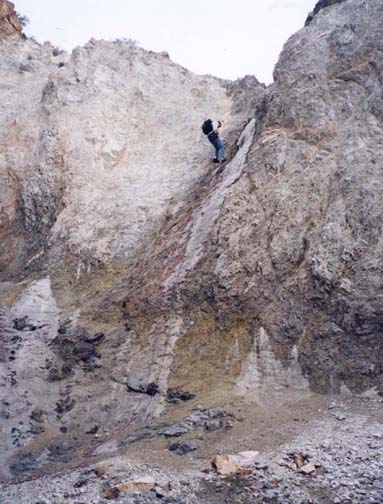
| First rappel | Third rappel |
Three rappels are required during the descent of this fractured headwall. The first is an 80ft descent for which a good anchor is a rock trapped under the huge boulder at the lip of the drop-off in the streambed (elevation 5520ft). Descend down to the loose scree in the streambed and then proceed further on foot to avoid the rocks inevitably cascading down below the next rappeller. Just below this scree is an awkward 10ft downclimb that, in turn, leads to the top of the second rappel, a 30ft descent that is readily anchored by the group of trees in the middle of the streambed. When we came this way in the winter this was an interesting, frozen waterfall. Another short stretch of scree follows before you arrive at an elevation of 5260ft at the top of the third rappel. This consists of scary-looking drop-off from a hanging slot. This was also a frozen waterfall when we descended in winter. The drop to the scree slope below is only 60ft though it looks much bigger when viewed from above. The anchor is a trapped rock under a large boulder some distance back from the lip.
A long scree-filled canyon descent follows this third rappel in the headwall and the route then transitions to a rocky, boulder-strewn canyon with pine trees and the beginnings of a running stream. You should reach this transition about 2hr 15min from the start. There are several modest downclimbs and, at 4840ft, a large gully enters from the left. As the rate of descent begins to lessen and the trees become more numerous, another large canyon and stream enter on the left at 4660ft. Then, at 4380ft there is a short section of narrows that begins with a 20ft waterfall in a rocky chute. This is best bypassed by downclimbing (with a belay) or rappelling a 20ft slot below a large tree on the left. Two more beautiful waterfalls follow almost immediately. The first, a vertical cascade about 30ft high can be rapelled using a tree anchor to the right of the stream. Alternatively, it can be bypassed by climbing to a small saddle on the left about 20yds upstream of the falls and, from that saddle, descending a scree chute to the bottom of the falls. The second waterfall, 20ft high, is also readily bypassed on the left by climbing to a low saddle and descending a leafy slope. You should reach this 4240ft elevation 1.3mi and 3.5hr from the morning start.
At the bottom of the leafy slope you will note the beginning of a use-trail that here follows a section of the old road that once penetrated up the South Fork. Follow the old road or use-trail on the north side of the broadening canyon and you will come to the remains of an old campsite complete with cooking pots! From here on the canyon bottom is frequently a boulder field and there is an episodic use-trail that usually proceeds along one or other side of the canyon to avoid the larger boulders. At 4200ft a large canyon and its wash enter on the left and at 3820ft, 1.7mi and 4hr from the start, you should arrive at the bottom of the first large boulder field. From this point on the canyon is more densely wooded and the use-trail sometimes follows the wooded southern bench and sometimes the more open, bouldery northern side.
At 3290ft, 2.8mi and 4hr 40min from the start, there is
a brief section of narrows, easily negotiated using the trail on the left.
Below these narrows, the South Fork emerges onto a broad boulder field as
it widens approaching the junction with the main Lytle Creek canyon. The
well-worn trail runs along the north side of this boulder field. A short
distance beyond the narrows, look for the spectacular Bonita Falls
that drop down the steep south wall of the canyon. After another 0.3mi,
the trail proceeds along the south side of two campgrounds and then arrives
at the main stream of Lytle Creek. It is not easy to find a place where
you can cross the river without getting your feet wet. And it could be
quite difficult, even dangerous, after prolonged rain. However, on the other
side it is just a few yards through the trees to the road and, hopefully,
the place where you left the return vehicle
(34o14.23'N 117o29.86'W,
elevation 2910ft).
The entire descent, 3.7mi long, should take about 5hr.
Last updated 1/27/02.
Christopher E. Brennen