ADVENTURE HIKES AND CANYONEERING
IN THE SAN GABRIELS
© Christopher Earls Brennen

|
|---|

|
Hike J3. Spring Canyon
- Hiking time: 4 hours
- Estimated hiking distance: 2.5 miles
- Elevation gain: None
- USGS Topo Maps: Cucamonga Peak, Devore
- Difficulties: Two rappels of 90ft and 200ft
- Special equipment: Rapelling equipment with one 200ft rope and a 200ft recovery line, 12ft of webbing, 1 rappel ring, helmets, harnesses.
-
ACA Rating: 3A II

Characteristics
The eastern end of the San Gabriels is riven through by the three forks of Lytle Creek that have created some rugged and beautiful canyons in this section of the mountains. The South Fork of Lytle Creek runs due east from the slopes of Cucamonga Peak and forms the northern side of a dominant ridge, the San Sevaine ridge, that also runs east from Cucamonga and overlooks the eastern end of the San Gabriel Valley. The north slope of San Sevaine ridge is particularly precipitous. Spring Canyon (as we have called it) is one of many small tributaries of the South Fork that drain this north slope and drop dramatically as they do so. In particular, Spring Canyon falls through two spectacular waterfalls, 90ft and almost 200ft in height. This hike accesses the top of Spring Canyon and follows the stream through its entire course down to Lytle Creek. It is a dry hike (though your feet may get wet) and is suitable for any time of the year.
Trailhead
This hike requires a four-wheel-drive shuttle. From Los Angeles take the 210 or 10 Freeway east toward San Bernadino and the 15 Freeway north toward Barstow. About 3mi before the intersection of the 15 and 215 Freeways in Devore, exit the freeway where the signs indicate the Lytle Creek recreation area. Drive north past Nealey's Corner toward Lytle Creek and, 1.6mi from the freeway, identify a left turn to a prominent white metal gate (34o12.10'N 117o26.92'W, elevation 2230ft). This is the entrance to the San Sevaine Flats road that you will shortly follow. Then continue on up the Lytle Creek road to the point where the South Fork joins the main Lytle Creek. We wish to identify a roadside parking area that overlooks this junction. It is 4.3mi north of the San Sevaine Flats road junction and 1.2mi beyond the Lytle Creek Ranger Station. It is also 0.14mi south of the road junction to the South Fork Campgrounds. Park one vehicle here (34o14.23'N 117o29.86'W, elevation 2910ft) and then drive back down Lytle Creek road to the gate to the San Sevaine Flats road.
It is possible to drive a 2WD vehicle up the rough dirt road that climbs up to San Sevaine Flats but it is not recommended; a 4WD vehicle is much preferred. It takes about 40min to drive the 7.5mi to the road junction where the access road to the radio towers forks to the right. Continue left (west) on the San Sevaine Flats Road for 0.45mi and park at the side of the road in a dip (34o12.66'N 117o30.71'W, elevation 5520ft).
Hike
From the 5520ft location where you parked (34o12.66'N 117o30.71'W) you should be able to locate a stile (four closely spaced posts) through the fence on the right side of the road. It is behind a tree just beyond where you parked and is roughly the third such stile from the Radio Towers junction. Proceed through that stile and head north (and slightly west) down into a gradually developing gully. This is a pleasant wooded canyon with only small sections of brambles and brush. As the gully deepens, grey bedrock appears and about a mile from the start, you encounter the first of a number of short downclimbs.
 | 
| |
|---|---|---|
| Spring Canyon Upper Falls | Spring Canyon Lower Falls |
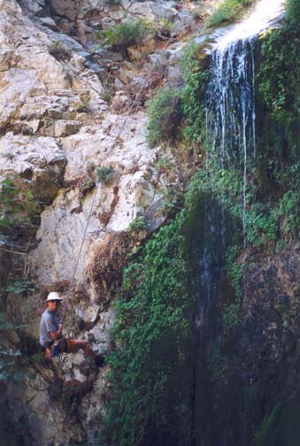
About 2hr and 1.2mi from the start at 3900ft a large gully enters on the right and you begin to encounter running water. Very shortly thereafter you come to an awesome drop-off, the top of the two beautiful waterfall rappels in Spring Canyon. It is a good place to pause, lunch and prepare for the excitement ahead. Below you is a drop of a little under 300ft in two vertical stages. Though it is hard to discern the bottom from your eerie perch, the rappels are technically easy and the anchors are robust.
The first stage is a 90ft vertical descent to the right of a beautiful moss- and fern-adorned waterfall. There are several possible anchors but the best is probably a stout tree on a ledge about 10ft above the lip on the right. This first rappel lowers you into a lovely wooded glade beside the waterfall. The second stage drops almost 200ft down from this glade. The best anchor is a large tree just to the left of the narrow lip. A single strand rappel from this tree using a 60m rope will just reach the bottom. About 2/3 of the way down this inclined and slippery rappel there is a sloping shelf with a tree on the right side that could, with some difficulty, be used to anchor a third stage if your rope is shorter than 60m. You should reach the bottom of the rappels (elevation about 3550ft) about 3hr and 1.3mi from the morning start.
There follows a section of descent over white bedrock with some downclimbing. A short distance from the bottom of the rappels, you will come to an inclined 50ft chute waterfall that is easily bypassed by downclimbing over the shoulder to the left. This is followed by a 30ft vertical drop that is best downclimbed in a slot on the left. Soon the canyon turns sharp right, opens up and passes to the south of two substantial knobs before entering a broad boulder field, the wash of the South Fork of Lytle Creek. You should reach this boulder field (elevation 3090ft) about 3hr 40min and 1.7mi of hiking from the ridgetop start.
Once in the wash, hike north across the South Fork stream bed to the north
side of the wash where you should be able to find a well-worn trail.
Travelling east, this trail proceeds along the south side of two campgrounds
and then arrives at Lytle Creek. Find a spot to cross the river; just a few
yards through the trees you climb the bank up to the road and, hopefully,
the parked return vehicle
(34o14.23'N 117o29.86'W,
elevation 2910ft). You should arrive here
just over 4hrs and 2.5mi from the start.
Last updated 9/17/03.
Christopher E. Brennen