ADVENTURE HIKES AND CANYONEERING
IN THE SAN GABRIELS
© Christopher Earls Brennen

|
|---|

|
Hike B3. Silver on the Side
- Hiking time: 8.5 hours
- Estimated hiking distance: 8.1 miles
- Elevation gain: 1850 feet
- USGS Topo Maps: Pasadena, Condor Peak
- Difficulties: About 11 rappels including three vertical drops of 100ft, 120ft and 180ft and some downclimbing.
- Special equipment: Helmet, harness and rappeling gear; 200ft rope, 200ft recovery cord, 50ft webbing and 8 rappel rings.
-
ACA Rating: 3A IV

Characteristics
Silver Canyon whose descent is described elsewhere in this collection has a big western tributary that runs in parallel to the main canyon for almost the entire northface descent of Mount Lukens, only joining the main canyon at the very end of that drop. Called ``Silver on the Side'', this western fork provides an excellent and exciting canyoneering adventure with big rappels near the end. It is relatively dry so take all the water you will need. Best for the winter, spring or fall, it could be too hot in the summer months, especially on the approach hike.
Trailhead
For this hike it is neccesary to leave a return vehicle in the parking area at the Stonyvale Picnic Area in Big Tujunga Canyon. Drive up Big Tujunga Road and turn right onto the road to Vogel Flat. At the bottom of the hill, turn left and go to the parking lot at the end of the road (34o17.08'N 118o13.40'W and elevation 1890ft).
Then, to reach the trailhead, drive the other vehicle(s) up the Big Tujunga Canyon Road to the junction with the Angeles Forest Highway. Turn right and drive to the junction with the Angeles Crest Highway at the Clear Creek Forest Service Station. Turn right and drive about 3mi down the Angeles Crest Highway to a place where a fire road climbs up from the road (it is about 6mi north of La Canada). As you go downhill, the Angeles Crest Highway makes a sweeping left turn at this point and there is a large dirt parking area on the right (34o15.62'N 118o11.54'W). The fire road that starts here is labelled 2N79.
Parenthetically we note that many of canyons that descend the slopes of Mount Lukens, including Silver, Suicide, Sutton and Hall Beckley, have three alternative approach routes, all of which provide access to the upper reaches of the Mount Lukens road. The first of these, included in the descriptions of the Silver and Suicide Canyon descents, starts on the Angeles Crest Highway at the 2N79 trailhead at 34o15.62'N 118o11.54'W and an elevation of 2940ft. The second, included in the description of Hall Beckley Canyon, also begins on the Angeles Crest Highway but at the trailhead for the Dark Canyon trail at 34o15.35'N 118o11.81'W and an elevation of 2730ft. The third, included in the description of Sutton Canyon, begins in Deukmejian Wilderness Park at 34o14.98'N 118o15.18'W and an elevation of 2335ft. The elevation gains up to the intersection of 2N76B and the Mount Lukens road (at 34o15.81'N 118o13.74'W, near the drop in for Silver Canyon) are respectively 1680ft, 1890ft and 2285ft; however the distances are respectively 5.4mi, 3.3mi and 2.8mi. The hiker can choose whether he or she would rather hike a longer distance or a greater elevation gain.
Hike
From the dirt parking area (34o15.62'N 118o11.54'W and elevation 2940ft), proceed past the locked gate and hike up fire road 2N79 that climbs toward the saddle you can see overhead. After 0.6mi (about 15min) you arrive at a junction at 34o15.72'N 118o11.43'W marked by a water tank a little distance away on the right. Here you connect with the Grizzly Flats Road. Take the left fork that doubles back toward the saddle (elevation 3410ft) which you should reach about 5min later. Here you will get a broad view to the north; Grizzly Flats is the grove of pine trees some distance directly below you and you may be able to see the Stonyvale parking area where you left the recovery vehicle.
 | 
| |
|---|---|---|
| 100ft rappel | Two-step rappel (Photo by Ken King) |
The fire road continues almost flat for a stretch as it passes a second saddle and, 40min from the start, arrives at a third saddle. Here, 1.7mi from the start at 34o15.68'N 118o12.22'W and an elevation of 3300ft, the road divides again. The left fork descends to Grizzly Flats. Take the right fork that climbs gradually, performs one major switchback at 3510ft, and eventually, 3.6mi and 1hr 20 min from the start, arrives at another fire road junction at 34o15.09'N 118o12.45'W and an elevation of 4010ft. The road you now join is the Mount Lukens Road that originates at the Forest Service station on the Angeles Crest Highway just a short distance above La Canada/Flintridge. It comes in from the left and continues on to the right toward Mount Lukens. You turn right and proceed along the road as it follows the ridge that eventually rises to the summit of Mount Lukens (elevation 5074ft). About 2hrs and 5.4mi from the start you will pass the junction with the spur road 2N79B at 4620ft. Beyond this junction the Mount Lukens road contours around to the south past a small summit before turning north to an abrupt switchback at 34o15.98'N 118o13.85'W, 4790ft, 0.4mi from the preceding road junction and 5.8mi from the start. This is the drop-in point and you should reach it 2hrs 20min into the hike. Between you and the Big Tujunga far below is a rugged and precipitous descent of about 3000ft.
Begin the descent by following a rough use trail that contours off to the left from the drop-in switchback. After about 100yds you should be able to find a branch of the use-trail that begins a steep descent just to the east of a developing gully. Though steep, the descent through this wooded area is easy, earthy and brush-free. Soon you will find yourself in an open gully that gradually deepens and is the beginning of Silver-on-the-side. After descending 700ft you first encounter bedrock and, shortly thereafter at 3970ft elevation and 50min from the drop-in, you arrive at the top of the first technical obstacle, a small 20ft rappel from a tree anchor on the right. This is almost immediately followed by a larger, 40ft rappel from another tree anchor on the right. A number of easy downclimbs follow before you arrive at 3690ft at a larger, 50ft boulder descent where many may choose to rappel from a tree on the left. This is immediately followed by another drop of about 15ft where, again, some may choose a belay line or a rappel anchored from a tree high up on the right.
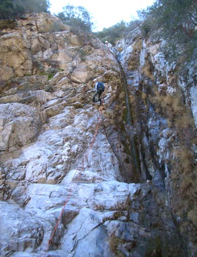
Beyond these obstacles, the gradient lessens and the going is easy for a lengthy section as you descend through 3300ft. This ends at 3210ft and about 2hrs from the drop-in (4hrs 20min from the start) when you suddenly arrive at a big drop-off. The first step is a 100ft vertical rappel from a tree anchor high on the right. This descends to a narrow slot with a small 15ft rappel from a bush anchor on the left, and, after some more downclimbs, leads to the top of a broad-lipped, 50ft rappel at 2930ft that is anchored by a bush on the right. This descends into a right-going slot that contains another 50ft rappel, a two-step drop that requires an anchor remake. The canyon then broadens out and over the next several hundred yards you pass through the extensive works of an operational marijuana farm at 34o16.39'N 118o13.04'W and an elevation of 2700ft.
|
|---|
| 180ft rappel |
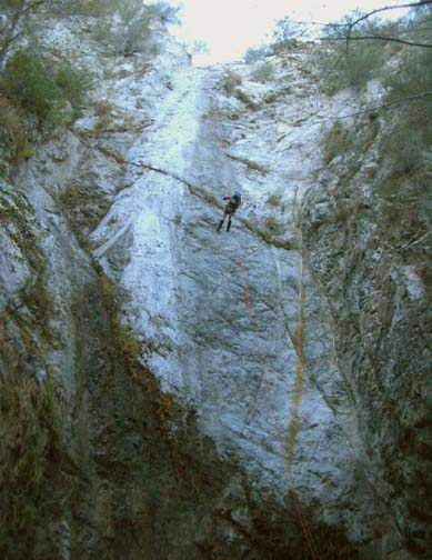
Downstream there is a little bushwhacking to do until at 2530ft and 4hrs from the drop-in (6hrs 20min from the start) you come to a sloping and slippery slot that might be downclimbed under dry conditions but is better rappeled from a bush anchor on the right. From there it is a short way to the top of an awesome two-step drop through a hard bedrock layer at 2270ft. The first step is a 120ft vertical rappel from a manzanita bush high on the right. This descends to a broad cliff-ringed platform, the narrow edge of which leads to a huge 180ft vertical rappel down into a wooded glade. The anchor for this 180ft descent is a solid bush high up on the lefthand cliff though you might choose to back this up with a tie=in to another of the bushes near the lip. If water were flowing in the canyon these two big rappels could be very challenging indeed so caution should be exercised in this circumstance. There is a bypass route on the right which can be accessed by climbing up to the ridge and following a rough and steep trail from there down to the junction with Silver Canyon.
Immediately below the 180ft descent at 2100ft there is a straightforward two-step rappel consisting of a 15ft drop followed by a 20ft drop that can be anchored from a tree at the lip. From the bottom of this last rappel it is only 50yds to the junction with Silver Canyon and another 100yds to the exit into the Big Tujunga. You should reach this exit at 34o16.54'N 118o12.90'W about 5hrs 30min from the drop-in and 7hrs 50min from the morning start having covered a total of 7.2mi.
From the exit, cross the Big Tujunga river and find the trail on the
far north side of the canyon. Turn left and follow the trail back to
the parking area at Stonyvale where you left the return vehicle(s) at
34o17.08'N 118o13.39'W
and an elevation of 1890ft. It should take about 8.5hrs to
complete this 8.1mi hike.
Last updated 1/28/06.
Christopher E. Brennen