ADVENTURE HIKES AND CANYONEERING
IN THE SAN GABRIELS
© Christopher Earls Brennen

|
|---|

|
Hike B4. Silver Canyon
- Hiking time: 9.2 hours
- Estimated hiking distance: 7.2 miles
- Elevation gain: 1680 feet
- USGS Topo Maps: Condor Peak, Pasadena
- Difficulties: 7 rappels including 2 over 100ft, much bouldering and downclimbing
- Special equipment: 200ft rope, 150ft recovery cord, 60ft webbing, 6 rappel rings, harnesses
-
ACA Rating: 3A IV

Characteristics
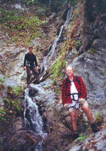
Silver Canyon is one of those marvellous north-facing canyons in the San Gabriels that provides an exciting canyoneering adventure with a minimum of brush. It is a very pleasant wooded canyon for most of the way. From the ridgetop close to the summit of Mount Lukens it drops 2700ft into the Big Tujunga in just 1.3mi, and is therefore one of the most precipitous canyons in the San Gabriels. The descent requires 7 rappels including two over 120ft in height. Consequently, this adventure is only for the experienced canyoneer. It is also a long and tough hike that requires a full day and is, therefore, best in the summer or early fall. In the winter or spring, the streamflow could make the hike difficult and dangerous.
Trailhead
For this one-way hike it is neccesary to leave a return vehicle in the parking area at the Stonyvale Picnic Area in Big Tujunga Canyon. Drive up Big Tujunga Road and turn right onto the road to Vogel Flat. At the bottom of the hill, turn left and go to the parking lot at the end of the road (34o17.08'N 118o13.40'W and elevation 1840ft).
Then, to reach the trailhead, drive the other vehicle up the Big Tujunga Road to the junction with the Angeles Forest Highway. Turn right and drive to the junction with the Angeles Crest Highway at the Clear Creek Forest Service Station. Turn right and drive about 3mi down the Angeles Crest Highway to a place where a fire road climbs up from the road (it is about 6mi north of La Canada). As you go downhill, the Angeles Crest Highway makes a sweeping left turn at this point and there is a large dirt parking area on the right (34o15.62'N 118o11.54'W). The fire road that starts here is labelled 2N79.
Parenthetically we note that many of canyons that descend the slopes of Mount Lukens, including Silver, Suicide, Sutton and Hall Beckley, have three alternative approach routes, all of which provide access to the upper reaches of the Mount Lukens road. The first of these, included in the descriptions of the Silver and Suicide Canyon descents, starts on the Angeles Crest Highway at the 2N79 trailhead at 34o15.62'N 118o11.54'W and an elevation of 2940ft. The second, included in the description of Hall Beckley Canyon, also begins on the Angeles Crest Highway but at the trailhead for the Dark Canyon trail at 34o15.35'N 118o11.81'W and an elevation of 2730ft. The third, included in the description of Sutton Canyon, begins in Deukmejian Wilderness Park at 34o14.98'N 118o15.18'W and an elevation of 2335ft. The elevation gains up to the intersection of 2N76B and the Mount Lukens road (at 34o15.81'N 118o13.74'W, near the drop in for Silver Canyon) are respectively 1680ft, 1890ft and 2285ft; however the distances are respectively 5.4mi, 3.3mi and 2.8mi. The hiker can choose whether he or she would rather hike a longer distance or a greater elevation gain.
Hike
From the dirt parking area (34o15.62'N 118o11.54'W and elevation 2940ft), proceed past the locked gate and hike up fire road 2N79 that climbs toward the saddle you can see overhead. After 0.6mi (about 15min) you arrive at a junction at 34o15.72'N 118o11.43'W marked by a water tank a little distance away on the right. Here you connect with the Grizzly Flats Road. Take the left fork that doubles back toward the saddle (elevation 3410ft) which you should reach about 5min later. Here you will get a broad view to the north; Grizzly Flats is the grove of pine trees some distance directly below you and you may be able to see the Stonyvale parking area where you left the recovery vehicle.
 | 
| |
|---|---|---|
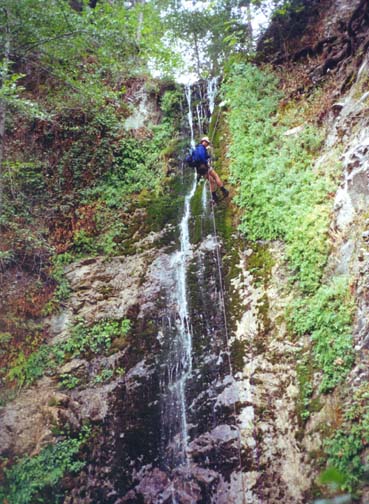
| The fifth rappel | The sixth rappel |
The fire road continues almost flat for a stretch as it passes a second saddle and, 40min from the start, arrives at a third saddle. Here, 1.7mi from the start at 34o15.68'N 118o12.22'W and an elevation of 3300ft, the road divides again. The left fork descends to Grizzly Flats. Take the right fork that climbs gradually, performs one major switchback at 3510ft, and eventually, 3.6mi and 1hr 20 min from the start, arrives at another fire road junction at 34o15.09'N 118o12.45'W and an elevation of 4010ft. The road you now join is the Mount Lukens Road that originates at the Forest Service station on the Angeles Crest Highway just a short distance above La Canada/Flintridge. It comes in from the left and continues on to the right toward Mount Lukens. You turn right and proceed along the road as it follows the ridge that eventually rises to the summit of Mount Lukens. About 2hrs from the start you will arrive at a saddle at 4600ft with a small water tank. This tank is not easy to spot; it is above you on the right. The drop-in to Silver Canyon (34o15.65'N 118o13.35'W) is at an obvious saddle at 4620ft about 100yds beyond the water tank and 4.9mi from the start. The road turns left here and the Silver Canyon gully drops down steeply from the edge of the road.
Between you and the Big Tujunga far below is a rugged and precipitous descent totalling 2680ft. This begins as soon as you leave the saddle. Though there are signs of passage by people or animals, you must push through the bushes in places. However, if you stay close to the developing gully, you will soon find brush-free passage and begin a long and steep descent in the rocky but normally dry streambed. About 1hr 15min from the drop-in at an elevation of 3440ft a substantial gully that is not indicated on the map enters from the right. Shortly thereafter, at 34o16.07'N 118o13.33'W and an elevation of 3160ft, you come to a junction that does show on the topo map. Here you join a large gully entering on the left. In fact, that gully is the main branch of Silver Creek and usually has some flowing water. From there you continue on down the wooded canyon and at 3040ft (about 3hr from the drop-in saddle) you arrive at the first rappel. Here the stream drops through two vertical steps, the upper one being about 20ft and the lower about 60ft. There are signs of a trail contouring over to a large gully on the left where there may be a downclimbing route but we did not explore that option. The rappel itself has a solid tree anchor in midstream at the lip and is an easy descent to the wooded canyon below.
It is only a short way from this first rappel to the second and third. Together these allow passage of one of the two major obstacles in Silver Canyon. The second rappel is a 70ft vertical drop for which we used a downed tree near the lip as the anchor. This lands you on a flat platform between the second and third rappels. The third rappel drops down about 120ft through an inclined rocky gorge. This requires a single rappel that is best anchored from a tree a short way up the slope on the left. The advantage of this over other possible tree anchors is that you can then see the anchor from the bottom during rope recovery. That recovery might otherwise prove tricky. We reached the bottom of the third rappel (elevation 2760ft) about 4hr after leaving the drop-in saddle.
After this major obstacle, there is a long section in which the canyon narrows considerably, in places to a water-filled slot. However, there are no difficult obstacles until you come to small, 30ft waterfall (at 2400ft) that can be downclimbed just to the right of the stream but is probably best rappelled along the same route (there are many small tree anchors). Not far beyond this at 2340ft is a 45ft waterfall that definitely requires a rappel (the fifth) and, as with almost all the rappels in this canyon, has a convenient tree anchor at the lip.
Another short section of canyon brings you to the top (at 2220ft elevation) of the sixth and penultimate waterfall in Silver Canyon. This is a very pretty 75ft vertical cascade covered in moss particularly near the top. It is anchored by a stout tree close to the lip. Just beyond the bottom of that waterfall is the top of the last and most difficult rappel in this adventure. It is a 120ft single rappel in two stages. First you drop about 20ft onto a substantial but anchorless platform. Viewed from above the stream then disappears over a narrow lip and turns left so that you cannot see the bottom. What you don't see is that the second drop is a vertical 100ft to the canyon floor. Since the rope recovery at the bottom must negotiate this left turn it is important to set up the single rappel carefully and for the last rappeller to ensure that the ropes are not twisted.
You should reach the base of this last waterfall (elevation 2080ft) about 6.5hr after leaving the drop-in saddle. From here it is an easy 15min hike to the exit from Silver Canyon (34o16.51'N 118o12.88'W and elevation 1920ft). At that point you will have descended 2680ft from the drop-in saddle over a distance of 1.3mi in a little under 7hrs. It is one of the most precipitious descents in all of the San Gabriels.
As you come to the end of Silver Canyon and emerge into Big Tujunga, veer right and you will immediately encounter the developed trail that climbs up behind your right shoulder to Grizzly Flats. You follow the trail in the opposite direction. Though the route to the car park is downstream to the left, it is easier to follow the trail as it goes around to the right. After about 50yds you then fork left, cross the river (Mill Creek) and proceed downstream along the broad trail on the north side of the canyon bottom. It is a 0.9mi hike back to the Stonyvale parking area.
Last updated 9/22/00.
Christopher E. Brennen