ADVENTURE HIKES AND CANYONEERING
IN THE SAN GABRIELS
© Christopher Earls Brennen

|
|---|

|
Hike D1. Saucer Branch
- Hiking time: 6.5 hours
- Estimated hiking distance: 5.7 miles
- Elevation gain: 200 feet
- USGS Topo Maps: Mt. Wilson, Pasadena
- Difficulties: Some downclimbing, one 70ft rappel
- Special equipment: 200ft rope, harnesses, a rappel ring, 10ft webbing
-
ACA Rating: 3A III

Characteristics
The Saucer Branch of Millard Creek in the mountains north of Altadena is best known to hikers of the Sunset Ridge fire road because, a short distance up that road, you get a fine view to the north of the spectacular waterfalls that guard the entrance to the Saucer Branch. This adventure hike takes you from Eaton Saddle on the Mount Wilson road, down the Mount Lowe fire road and along the firebreak to the Tom Sloan Saddle. The off-trail section begins when you leave the firebreak to drop into the bowl (or saucer) that feeds the Saucer Branch of Millard Creek. It is a pleasant, open canyon with a number of interesting artifacts and a spectacular cliff halfway down. The only technical challenge are the waterfalls just before the canyon end but even these can be bypassed for those who do not want to rappel. It is ideal for a late fall or early winter day before the rains have arrived.
Trailhead
This hike requires a car shuttle. First you should deposit the return vehicle by the gate at the bottom of the Sunset Ridge Fire Road. From Loma Alta in Altadena, drive up the Chaney Trail to the top of the ridge. The left fork here descends to Millard Picnic Ground. Park by the gate at the end of the short right fork (34o12.88'N 118o8.72'W and elevation 2090ft). Then, in the other vehicle, descend into Altadena and up the Angeles Crest Highway to Red Box junction. Turn right here onto the Mount Wilson Road and drive 2.3mi to the overlook at Eaton Saddle (34o14.36'N 118o5.60'W and elevation 5090ft). Park in the broad dirt area here.
Hike
Proceed past the gate at Eaton Saddle (34o14.36'N 118o5.60'W and elevation 5090ft) and along the fire road, through the short tunnel and up to Markham Saddle (elevation 5270ft), 0.5mi and 10min from the trailhead. Past Markham Saddle, the fire road contours over to behind Mount Lowe and then west along the south side of Bear Canyon and high above it. Approximately 1.8mi and 45min from the trailhead, the road makes a 180 degree turn around the head of the ridge. At this point (34o14.07'N 118o7.06'W and elevation 4890ft) you proceed straight on along a small spur road, past a water tank to a wide clearing used as a helicopter pad. The trail down to Tom Sloan Saddle is well marked and leaves from the far side of the clearing. A well-maintained trail with excellent views it proceeds down the apex of the ridge. Three miles and 1hr 15min from the trailhead, you arrive at Tom Sloan Saddle (34o14.13'N 118o7.80'W and elevation 4070ft) where trails down to the Dawn Mine in Millard Canyon, down into Bear Canyon and along to Mount Lowe campground all converge. Do not take any of these but continue on the use-trail that follows the apex of the ridge (firebreak) in a westerly direction. This climbs steeply at first and then proceeds over and around a series of rocky knobs. From the top of the first prominence take time to survey the surroundings to the southwest. You should identify the first substantial lateral ridge west of Tom Sloan Saddle that runs south from the main ridge you are following. Notice also a white rock prominance on that ridge a short distance south of the main ridge. The use-trail follows the main ridge and, about half a mile from Tom Sloan Saddle (3.45mi from Eaton Saddle) passes along the north side of the rocky knob where the lateral ridge meets the main ridge. You need to be aware of this and to climb to the top of that rocky knob (34o14.13'N 118o8.20'W and elevation 4320ft). From this vantage point it looks as though there is nothing but solid brush between you and the white rock prominance below you on the lateral ridge. However, if you start down the apex of the lateral ridge there are just a few places where you must push through heavy brush. There are also some clear sections. Head toward the white rock prominance and, about 10yds before it, veer right down toward the apex of the small spur ridge that runs west from it. A short way down that ridge you will see an open draw heading down into the gully on the south side of the spur ridge. Follow this draw to the bottom of the gully and follow the gully down to a junction with two other gullies. You have now reached the bottom of the large bowl-like catchment area that feeds the Saucer Branch of Millard Creek.
 | 
| |
|---|---|---|
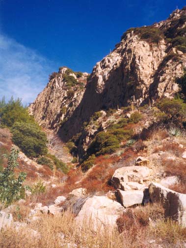
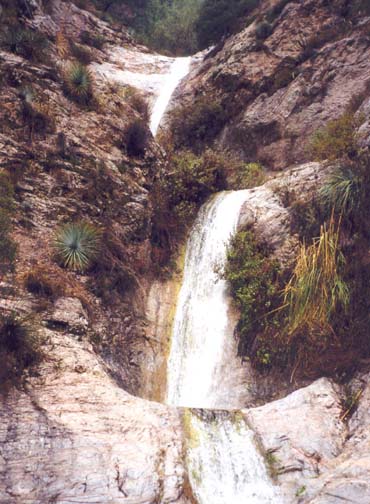
| Cliffs in Saucer Branch | Saucer Branch Waterfalls |
From this point on (3950ft, 2hr 30min from trailhead), you will follow the stream bed all the way to the end of the Saucer Branch. Just 100yds downstream from the junction of the gullies, you will arrive at the only significant obstacle in the upper canyon, a 25ft dryfall where there are two alternatives. The first is a rough exposed use-trail to the left of the lip that contours around to a point where you can downclimb. The alternative is to follow the animal trail up to the ridge on the left about 25yds upstream of the falls, and then down-climb the steep apex of the ridge to a point downstream of the falls. Once you reach the streambed again, go back up to the dryfall; there is a horizontal mine shaft hewn out of the rock near its base.
Downstream of the dryfall, the stream has cut to the bedrock and the going is fairly easy as you gradually enter a more wooded and shady canyon. About 3hr from the start at an elevation of 3600ft you will come to another 25ft dryfall that is easily bypassed by the trail on the left. This second dryfall drops you into a broad, shady and fairly flat area that may have been the site of an encampment at one time. Just to the right of the streambed is the wreckage of an aircraft, a Nordyn Norseman, that crashed here on May 13, 1948. This same canyon contains the remains of an unusual ``hanging cabin'' that, according to John Robinson, one brave goldminer attached to a cliff somewhere in the Saucer Branch.
As you near the downstream end of this broad, wooded clearing, the canyon closes in and 3.6hr from the start at an elevation of 3400ft you will arrive at the top of a long, steep rocky glen where the going is much slower. A rough use-trail proceeds down the earthy slopes to the right of the rocky streambed. Eventually, 4hr from the start at an elevation of 3100ft, you reach the bottom of the rocky glen and also emerge from the woods. Almost immediately, you will approach a place where the use-trail climbs a short distance up onto a scree bench on the left. Look for the ducks that I left to mark this transition. It is important to identify this point because the use-trail that descends the other side of this scree bench is much easier going than the streambed. This stretch of the canyon is spectacular because of the high cliff on the left; rockfalls from this cliff have formed the scree bench that you surmount and descend. About 4.5hr from the trailhead at an elevation of 2800ft you will reach the streambed again at the bottom of the scree slope. Downstream of this point, the use-trail proceeds along the left side of the canyon and about 4.8hr from the start, enters an overgrown section of canyon where the going is quite slow.
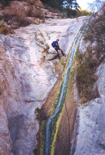
This overgrown section ends when you suddenly arrive at the top of the series of waterfalls near the end of the Saucer Branch (5hr from the start at elevation of 2600ft). The first of these is a 70ft waterfall that is a relatively simple rappel. A large metal bolt embedded in the rock on the right side of the lip provides a good anchor, though it would be wise to back it up with webbing to the tree on the right. There is a second metal bolt nearer to the lip and further to the right but that would make it more difficult to stay out of the pool at the bottom. In fact, near the bottom of the rappel, you should transition from the right side (looking downstream) to the left side of the stream in order to land on a dry bench.
|
|---|
| 70ft Waterfall |
There are two other ways to bypass this 70ft waterfall. At the lip you will notice on the right side a very exposed semi-trail that starts at the lip and contours around to a bluff that could be downclimbed. This is dangerous and should not be attempted. If you wish to avoid the rappel, hike about 30yds back up the canyon. There, on the left side (looking downstream) you should be able to identify a steep, earthy slope with many signs of passge. Climb up this slope and find a rough use-trail that contours around and then descends a steep gully to a point downstream of the series of waterfalls.
At the bottom of the rappel down the 70ft waterfall, you will encounter two more waterfalls, both about 25ft high. These are best bypassed by following the use-trail around to the right. Climb about 6ft up on the rock to access the top of this trail that is somewhat exposed for the first 10ft but thereafter is relatively safe. The trail continues downstream at some height above the stream on the right but I recommend descending to the bottom and then climbing up the rock to admire the three waterfalls from below.
Climbing back up to the trail after this excursion, it is only about
100yards from there to the end of the Saucer Branch. You should reach
this point
(34o13.20'N 118o8.25'W and
elevation 2380ft) about 6hr and 4.7mi from the start.
Turn right
and follow the well-used trail along the main branch of Millard Canyon.
About 0.25mi down the canyon, you need to identify the point where
the trail climbs up to the left
(34o13.16'N 118o8.47'W and
elevation 2190ft). If you miss this you will arrive
at the top of Millard Falls and have to backtrack. The trail climbs briefly
and then contours around two spectacular amphitheaters before emerging
from the canyon and joining the asphalt Sunset Ridge fire road.
About 300yds down the road you will come to the gated trailhead where
the return vehicle was parked. You should reach this gate
(34o12.88'N 118o8.72'W and
elevation 2090ft) about 6.5hr from the start, having hiked
5.7mi.
Last updated 9/9/99.
Christopher E. Brennen