ADVENTURE HIKES AND CANYONEERING
IN THE SAN GABRIELS
© Christopher Earls Brennen

|
|---|

|
Hike G9. San Antonio Creek
- Hiking time: 7 hours
- Estimated hiking distance: 4 miles
- Elevation gain: 2000 feet
- USGS Topo Map: Mount San Antonio
- Difficulties: 6 rappels (one in a waterfall) and much boulder hopping
- Special equipment: 200ft rope, rappelling equipment, helmets, 40ft webbing, 3 rappel rings and drybags
-
ACA Rating: 3B III

Characteristics
The southeastern flank of Mount Baldy consists of a great rock-rimmed bowl that has attracted skiers and other adventurers for the last century. In the days before ski lifts, the Sierra Club built an alpine hut in the focus of this bowl to shelter the intrepid skiers of those days gone by; and still today hikers and skiers make use of this shelter. San Antonio Creek drains the great bowl, burbling past the steps of the hut as it begins its descent toward the great canyon down below. While steep, the first part of this descent is relatively benign as the stream tumbles down over epochs of boulders. But as it approaches Manker Flats, the stream enters a dramatic vertical gorge where the water flies airborne over four large waterfalls known collectively as San Antonio Falls. The descent of these falls represent the crux of this adventure hike.
Trailhead
From the cities of Claremont or Upland drive north up Mills Avenue or Padua Avenue to Mount Baldy Road. Follow Mount Baldy Road into the mountains (San Antonio Canyon), proceed through Mount Baldy Village, past the turn-off to Icehouse Canyon and up to the trailhead at Manker Flats (34o15.96'N 117o37.60'W, elevation 6160ft) just a few hundred yards short of the end of the road at the Baldy Notch Ski Area parking lot. The fire road that you will follow branches off to the left, blocked by the ubiquitous steel gate.
Hike
Proceed up the initially asphalt-covered fire road as it contours into the canyon of San Antonio Creek. After just 15min and 0.6mi from the trailhead, you come to the hairpin bend (34o16.24'N 117o37.96'W, elevation 6370ft) where you have a spectacular view of San Antonio Falls as they crash down the vertical gorge to the broader boulder-strewn canyon bottom. Take a few moments to proceed along the use-trail to the base of the falls, paying particular attention to the descent route described later. Once ready, go back to the fire road and continue along it as it climbs out of the canyon of San Antonio Creek again and turns north. About 150yds after that turn out of San Antonio Canyon, 0.4mi from the hairpin bend and 1mi from the start, you will come to the place where the trail leaves the road and climbs the slope on the left. This trail junction (34o16.10'N 117o37.70'W, elevation 6580ft) is not signposted and is easily missed so be alert as soon as you make the turn out of San Antonio Canyon. There is a trail-log table a short way up the trail that will confirm that you are on the right track. Soon the trail contours back into the canyon of San Antonio creek and there are several marvellous viewpoints where you can inspect the falls from high overhead. Higher up there are other places where you can view the more benign cascades above the waterfalls. In total, the climb to the Sierra Club hut (34o16.88'N 117o38.34'W, elevation 8150ft) is about 2000ft and it takes about 2hrs to cover the 2.5mi from the trailhead. The green hut is visible from far below and the last part of the climb seems endless as the hut appears closer than it is. Just about a hundred yards before the shelter the trail contours into the channel of San Antonio creek and there are several obvious drop-in points.
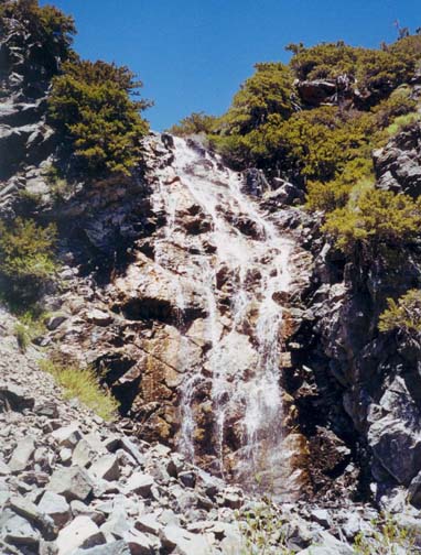 | 
| |
|---|---|---|
| The first waterfall | Third falls from bottom |
Initially the off-trail descent along the creek is rocky and moderately steep. Then, about 45min from the drop-in point, you arrive at the only substantial obstacle in the upper canyon, a 60ft waterfall that is not visible from the trail on the way up. There are several ways to negotiate this waterfall. We rappelled down to the right of the falls using a wizened old tree to the right of the lip as our anchor. The rock here is very fractured so helmets are recommended to avoid injury from falling rocks. If, however, you would prefer an alternate, there is a gully some distance to the right that can be used to descend. It can probably be reached by backtracking and then contouring and bushwhacking over to the right.
Below the waterfall there is another stretch of rocky descent where a faint use-trail follows the left bank of the stream. About 1hr 30min from the drop-in point, this culminates in a huge scree slope, almost a moraine blocking the canyon. Here you slide alot as you descend some distance to the right of the stream. During this descent, you might note a large and distinctive white boulder in the canyon a short distance downstream of the base of the scree slope. About 15min later, when you get to that point, you will encounter a substantial waterfall cascading down a rockface to the left of the boulder. The way to bypass these falls is to proceed down a sandy slope to the right of the boulder.
After boulder falls, the going becomes more rugged and you encounter a series of small waterfalls that can be negotiated or downclimbed. Then about 2hr 15min from the drop-in point, you arrive at the top of the series of spectacular waterfalls that constitute San Antonio Falls and the primary challenge of this adventure hike. The first of these waterfalls is a modest 40ft cascade that is really just a continuation of the series you have been negotiating by downclimbing. This too can be downclimbed on the right where there are many good foot and hand holds but a belay is recommended. There are several rocks and small bushes that can serve as anchor for this belay.
A few yards downstream of these first falls you arrive at a natural rock platform where you can overlook the remaining four waterfalls and the dramatic gorge of San Antonio Falls. The canyon bottom can be seen far below you. The 40ft second falls fly off the left side of this platform into a rocky, spray-filled slot or cauldron where they make an abrupt right turn. Following the route of these falls is clearly inadvisable for you would end up in the watery maelstrom at the bottom of this slot. Instead there are two possible descent routes, one to the right and one to the left of the waterfall. The most spectacular would be to rappel off the right side of the platform. The problem here is the absence of a satisfactory anchor. The small stout bushes on the right wall could be used but need the back-up of several pitons. We opted for the much easier but less spectacular route on the left. Cross the stream and follow the use-trail up to the ridge on the left side of the canyon. The large, wizened tree on the ridge top can be used to anchor the sloping descent down the rocky ridge that defines the left wall of the stream course at this point. This 90ft rappel (that could also be downclimbed fairly safely) places you below the second falls and just a short distance upstream of the lip of the third falls. However, a small but awkward cascade separates you from that lip. The trick here is to descend via a slot to the right of this small cascade.
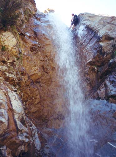
You will now have arrived at the biggest challenge of this adventure, the third falls that disappear over a narrow lip and crash 80ft down a vertical, spray-filled slot to a gravel platform far below. The anchor for this descent is a large bush that may require a long piece of webbing in order to encircle its dispersed base. With a 200ft rope you can set up a double-strand rappel. The main problem is that the descent is very wet indeed, and you will be hammered by the falling water during the descent so place all valuables in dry bags and remove any glasses or hats that would inevitably be torn away. I was glad of the helmet that helped deflect some of the crashing water. The initial part of the descent is down a narrow slot to the left but this angles back into the main stream about 20ft below the lip and from this point on the descent is very wet indeed.
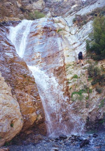
|
|---|
| Last waterfall |
The fourth falls follow immediately and are a more modest 50ft cascade. There is a use-trail on the right that can be used to downclimb these fourth falls, following a broken angling ledge to the bottom. However, for safety we set up a simple (and dry!) rappel using the tree at the top of the trail on the right. This then brings you to the top of the fifth and last waterfall, an 80ft drop with a hiccup in the middle. Here there are two ways to descend. There is a ledge or groove to the right of the waterfall that many people use to climb from the canyon bottom to the top of this lowest waterfall. The descent here is a little airy but quite straightforward. However, it is more fun to rappel down the dry face to the left of the waterfall. For this purpose, a large boulder in the center of the stream can be wrapped to serve as the anchor, using a long piece of webbing to encircle it safely. You may well have a substantial audience for these last few rappels for the base of San Antonio Falls is a popular hiking destination for families.
You should arrive at the bottom of the falls about 4hrs 30min
from the drop-in point, now high above you. After drying off a little,
hike back up the short and well-travelled use-trail on the left
side of the canyon to the hairpin bend
in the fire-road that you passed many hours ago
(34o16.24'N 117o37.96'W,
elevation 6370ft). It is an easy 15min stroll from
there back down the road to the trailhead
(34o15.96'N 117o37.60'W,
elevation 6160ft)
and the end of a great adventure hike
down San Antonio Creek.
Last updated 6/1/00.
Christopher E. Brennen