ADVENTURE HIKES AND CANYONEERING
IN THE SAN GABRIELS
© Christopher Earls Brennen

|
|---|

|
Hike G8. San Antonio Ridge
- Hiking time: 13.5 hours
- Estimated hiking distance: 13.4 miles
- Elevation gain: 2270 feet up to Mount Baldy summit
- Elevation loss: A total of 10000 feet of steep descent
- USGS Topo Maps: Mount San Antonio, Mt. Baldy, Glendora
- Difficulties: A very long and exhausting hike requiring at least 5 litres of liquid; some scrambling and climbing
- Special equipment: None needed
-
ACA Rating: 2A IV

Characteristics
A long and, in places, dramatic ridge runs from Mount San Antonio (Mount "Baldy") west to the 8007ft summit of Iron Mountain. Called San Antonio Ridge, this rugged spine at 7000-8000ft elevations makes for a spectacular but very challenging adventure hike. It begins with an ascent of Baldy and then a descent down along the apex of the ridge. This is the beautiful high country of the San Gabriels and the first part of the traverse is relatively easy going with great vistas off to both sides, and especially abrupt drops into Fish Fork to the north. As you come within a mile or so of Iron Mountain, the going gets much harder. Here the ridge is interrupted by several notches where the terrain falls away awesomely on both sides. Coming from the east, the first of these is called Gunsight Notch. Many parties have turned back here, overwhelmed by the vertical terrain and the loose rock. In fact, there is a fairly easy route across Gunsight Notch (described below). But there remain many more challenges along the rugged ridge to "Big Bad Iron". And once on the summit, you are still faced with a very long and, in places, rough descent to the East Fork trailhead.
The hiking difficulties of the San Antonio Ridge are compounded by two other problems. Most obvious is the need for the long car shuttle between the East Fork trailhead and the Mount Baldy ski lift parking lot. Much more problematic is the issue of whether to attempt to do it as a dayhike or as an overnight hike. In the former case you can travel fast and light but it is almost inevitable that you will have to hike part of the way in the dark. An overnight hike implies manoevering a heavier pack through some tight and steep places. It also means carrying much more water (perhaps eight quarts per person as opposed to five on the dayhike). Note that there is no water available anywhere along the route and almost everyone underestimates the water required on this hike.
Because of the summer heat or winter snow, the hike is probably best in the late spring or fall.
Trailhead
The first step in setting up the car shuttle for this adventure is to drive two vehicles up highway 39 into the mountains north of Azusa. After passing the Morris and San Gabriel Dams, turn right onto the East Fork road and follow this for about 6mi, past the junction with the Glendora Mountain Road and over the Cattle Canyon bridge to the trailhead parking area (34o14.21'N 117o45.92'W, elevation 2030ft) next to the East Fork Ranger Station. Park the return vehicle here and then drive back to the junction with the Glendora Mountain Road.
Fork left and follow the Glendora Mountain Road up onto the ridge and east to the junction with the Mount Baldy Road in Mount Baldy Village. Turn left and follow Mount Baldy Road up to the end in the parking lot for the Mount Baldy Ski Area (34o16.20'N 117o37.32'W, elevation 6480ft). Park here near the bottom of the ski lift to the Mount Baldy notch.
Hike
The first task is to reach the top of Mount Baldy early in the morning and here you are faced with a choice. You can either begin at dawn and hike up the steep trail from the ski lift parking area to Mount Baldy Notch or you can wait for the ski lift to open about 9am (sometimes earlier) thus saving some energy but losing valuable daylight. My own judgment is that it is better to forego the ski lift and get to the Notch before 7am. But the times and distances given below are measured from the Notch.
|
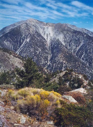
|---|
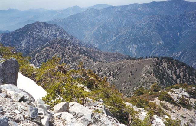
| San Antonio Ridge from West Baldy |
From Baldy Notch (34o16.47'N 117o36.62'W, elevation 7775ft) follow the standard route to the summit of Mount Baldy. First follow the dirt road that crosses and recrosses the ski area up to the top of Ski Lift #4. From there the trail proceeds along the crest of the dramatic Devil's Backbone before traversing around to the south side of Mount Harwood (elevation 9552ft). The trail flattens as it follows the ridge between Harwood and Baldy but then steepens for the final climb up the scree slope to the summit of Baldy (34o17.35'N 117o38.77'W, elevation 10064ft). You should reach this point, 3mi from the start, after 1hr 50min of hiking.
From the summit of Baldy it only takes about 15min to hike the 0.5mi along a use-trail to the 9988ft twin summit known as West Baldy (34o17.21'N 117o39.27'W). You should pause here to recognize Iron Mountain off to the west with the San Antonio Ridge wandering over toward it via a number of saddles and prominences. The route down along the Ridge is easy to identify. A use-trail follows the apex of the ridge and descends quite steeply in places over rocky ground covered with low scrub. The right side of the ridge top tends to be a little easier and less brushy than the left but you should not drift too far from the apex especially as the foliage transitions from scrub to pine forest in which it is less easy to see ahead. About 1hr 15min into the descent you should come to a very clear open saddle just below the pine forest. You should reach this 7772ft saddle (34o17.61'N 117o40.39'W), 4.8mi and 3hr 15min from the start.
The next section along a fairly level and open ridge top is easy going. After a brief descent you climb gradually to a low summit (elevation 7903ft) and then descend again to a second saddle (7367ft) about 0.8mi from the first. Beyond this is a slightly more strenuous climb of 400ft to a more prominent high-point. This 7758ft summit (34o17.46'N 117o41.72'W, 4.5hr and 6.1mi from the start) is an excellent place for an overnight camp should you have decided on a multiday trip. There are flat areas and flat rocks on top to serve as sleeping or eating places.
 | 
| |
|---|---|---|
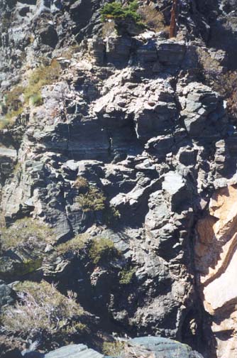
| Gunsight Notch from east side | Notches from the escape ridge |
Beyond campsite peak the ridge descends more steeply to the first major obstacle on the ridge, Gunsight Notch (34o17.39'N 117o42.01'W, an elevation of 72805ft, 6.4mi and 4hr 50min from the start). Viewed from just above the final steep descent to the low point of the notch, Gunsight appears to be a formidable hurdle requiring technical climbing equipment. Moreover the terrain falls away dramatically on both sides leaving little hope of crossing at lower elevations. In fact the route across Gunsight Notch is relatively easy and can be achieved safely without even a belay. But before attempting the crossing you should carefully assess your condition, the daylight remaining and your water resources. If any are marginal you might seriously consider retreating. There are two retreat options. The most obvious is to go back the way you came and this is the primary recommendation. There is however a second possibility that will take you to water within a few hours. This second escape route proceeds along the lateral ridge that branches southward from San Antonio Ridge at a point just east of Gunsight Notch. We digress briefly to describe that route.
[Secondary Escape Route: The secondary escape route starts from the east side of Gunsight Notch. First you transition south east and downwards to a scree slope that leads onto the west side of a lateral ridge running southwards. Proceed along the scree slope just below the ridge crest until you encounter the wire cables of the Gold Dollar Mine strewn down the western slope of the escape ridge. Descend along the route of the cables to a main shaft with tipping structure and then continue on down the route of the cables to a wooden shelter with bed and lantern. It is important to locate this hut because the next part is tricky; you must contour along a narrow ledge to the left (south) and locate the trail that was used to access the mine. After paralleling the ridge spine for a short distance, the trail reaches the ridge summit and descends along it for some distance. At a point where the ridge spine steepens, try to find the much less distinct trail that reverses direction and contours along to the north into Coldwater Canyon on the east side of the escape ridge. Eventually this trail peters out and you must find a way to scramble down one of the steep gullies into Coldwater Canyon where there is welcome water. From here proceed down Coldwater Canyon to the Widman ranch and then follow the road all the way to the intersection with Cattle Canyon. Continue downstream all the way to the Cattle Canyon bridge on the East Fork Road. Turn right and walk up the road to the East Fork Trailhead where you left the return vehicle. From Gunsight Notch to this trailhead takes about 7.5hr.]
 | 
| |
|---|---|---|
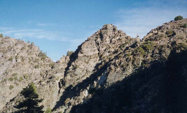
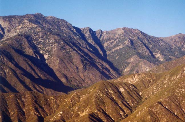
| Left: Iron Mountain. Center: Notches | Baldy and Ridge from Iron Mountain |
Resume Ridge Hike: Assuming you have decided to continue along the ridge to Iron Mountain, the following is the route across Gunsight Notch. Descend on the left side of the ridge to the low point of saddle in the Notch. From there, descend to the left on the west side and follow a short shelf to where a steep but readily climbable gully ascends. Climb up this gully to the apex of the rocky ridge beside a large dead tree. Then proceed straight up the rocky apex of the ridge to the flat top on the west side of Gunsight Notch. The ridge climb is easy but a little airy. The route then follows the flat top and descends directly into the second notch. From the saddle point in the second notch climb up a few feet and contour flat left along a ledge for about 20yds. Then climb up a few feet and ascend diagonally up to the right to the apex of the rocky ridge on the west side of the second notch. Follow the apex of the ridge to the flat top on the west side of the second notch. It will take about 40min to cross both notches.
The rest of the route to the summit of Iron Mountain is simply a matter of following the ridge top, though this gets quite rugged in places. About 5hr 45min from the start you cross a small notch of white rock (7300ft) and 15min later a rugged, rocky ridge top that requires a little climbing to surmount the largest outcropping; I called this the Witches Backbone. Another hour of steep climbing is needed before you finally arrive, 7hr and 7.3mi from the start, at the summit of Iron Mountain (34o17.30'N 117o42.80'W, elevation 8007ft). It is not for nothing they call this "Big Bad Iron".
The descent from the summit of Iron Mountain to the East Fork trailhead has been described elsewhere in the Iron Mountain hike. It is a long and arduous task. It takes about 2.5hr to descend the 2.3mi to the 4580ft saddle (34o15.53'N 117o43.38'W) where the Iron Mountain trail joins the old Allison Mine trail and where you transition to the better-maintained Heaton Flats Trail. If you do the San Antonio Ridge as a day hike it is almost inevitable that you will do the last part in the dark so it pays to have hiked the Heaton Flats Trail before. From the 4580ft saddle it is another 3.3mi down the Heaton Flats Trail to Heaton Flats by the East Fork of the San Gabriel River. Turning left you finally hike south along the dirt road to the East Fork Trailhead (34o14.21'N 117o45.92'W, elevation 2030ft). The total distance for the hike is about 13.4mi and it should take about 13.5hr.
Last updated 9/20/02.
Christopher E. Brennen