ADVENTURE HIKES AND CANYONEERING
IN THE SAN GABRIELS
© Christopher Earls Brennen

|
|---|

|
Hike D4. Rubio Canyon
- Hiking time: 5.5 hours
- Estimated hiking distance: 4 miles
- Elevation gain: 1408 feet
- USGS Topo Maps: Mount Wilson, Pasadena
- Difficulties: Five or six rappels ranging in height from 15ft to 80ft, several with flowing water.
- Special equipment: Rapelling equipment with a 160ft rope, a 120ft rope, 50ft of webbing, 6 rappel rings and dry bags.
-
ACA Rating: 3B II

Characteristics
This hike presents the adventurer with a special combination of intriguing stories of human endevour and the challenges of a precipitous canyon in the foothills north of Pasadena. It involves a straightforward trail hike to the top of the historic promontory known as Echo Mountain followed by a descent through the rugged Rubio Canyon. Rubio is a relatively small canyon that begins on the southern slope of Mount Lowe, swerves to the east as it runs behind Echo Mountain and then turns south again as it emerges from the mountains.
The history of this region took a dramatic turn in 1892 when the balloonist, inventor and Pasadena entrepreneur Thaddeus Lowe and the engineer David Macpherson began construction of their mountain railway to the top of Echo Mountain and beyond. Opened in 1893, the railway consisted of a long extension of the Pasadena tramway system up and into Rubio Canyon. This tramway penetrated about 0.5mi into the mountains; the present rough trail into Rubio follows what remains of the road bed and a few old ties can still be discerned in places. At the terminus of this tramway inside Rubio Canyon, Lowe built a substantial pavilion on a wooden trestle spanning the canyon and, until it was severely but inevitably damaged in a winter storm flood, this pavilion was a major tourist attraction. Wooden walkways and staircases were built up and down the canyon to allow visitors to enjoy the beauty of the wilderness. Of course, almost nothing remains of these facilities but many old photographs survive to remind us of the details. From these we know that a wooden staircase and walkway up the canyon climbed several substantial waterfalls before terminating at the base of the much larger and more spectacular Thalehaha Falls, called Bridalveil Falls by some. All that remains today are a few anchors in the rock where the walkways were affixed. The last part of this adventure involves a series of rappels down these historic waterfalls.
To summarize the rest of the history, Lowe and Macpherson then built a dramatic cable railway from the Rubio pavilion up the steep slope to the top of Echo Mountain. Hotels and other facilities were constructed on the summit and the settlement became known as the White City. They then built another tramway leading from Echo Mountain and the White City on up to Crystal Springs at the base of Mount Lowe, a distance of about four miles. Another rustic inn and resort were constructed at Crystal Springs.
Unfortunately, these world-renowned resorts and engineering feats were no match for the furies that nature visits on the San Gabriels at regular intervals. Every few years fires, storms, rock slides or high winds would cause major damage to some part of the railways or the tourist complexes. Thaddeus Lowe soon became bankrupt and subsequent owners were equally unsuccessful. In 1937, the entire complex was abandoned and nature began the process of absorbing the remains (with a little help from the Park Service who removed whatever dilapidated structures were left). Now only foundations remain on Echo Mountain and almost all trace of the facilities in Rubio Canyon have been swept away. A few sparse remnants still exist to allow imaginary reconstruction of the vanished grandeur. Of course, the lovely waterfalls in Rubio Canyon still remained to be enjoyed by many generations of hikers.
In the summer of 1998, earthmovers high above the west wall of Rubio Canyon caused a huge landslide that covered all the features decribed below from midway down Thalehaha Falls to a point just downstream of Moss Grotto Falls. Two huge canyon-filling rockpiles were created. One stretched from about 30ft above the base of Thalehaha Falls to the narrows downstream of Suspended Boulder Falls. The other much larger rockpile stretched from just downstream of the first pile to downstream of Moss Grotto Falls with its apex roughly above Mirror Lake. At that point the second rockpile was about 50ft deep.
For several years it was unclear whether the perpetrators of this terrible destruction of our natural and historic heritage would be called to account for their despicable acts. Even the Forest Service seemed intent in trying to deny its dubious role in approving the earthmoving and in avoiding any subsequent remedial actions. Then, nature herself intervened. On the night of October 19/20, 2004, and extraordinary event occurred in Rubio Canyon. After an intense rainstorm, a flash flood high in the east fork of Rubio came careening down into the main canyon and crashed over Thalehaha Falls. The energy it gained in its near 100ft drop down Thalehaha agitated the upper rockpile to such a degree that it initiated a remarkable debris flow. This awesome debris flow swept down the narrow Rubio gorge and set in motion almost the entire rockpile, consisting of up to 4ft in diameter. Once it hit the flatter canyon bottom downstream of Moss Grotto Falls the debris flow began to slow down. Most of the huge rocks appear to have come to rest within the next hundred yards creating a new canyon floor about 20ft higher than before. Smaller rocks, gravel and sand travelled much further, even as far as the debris basin about a mile downstream.
The result of this extraordinary event was that the original falls were largely uncovered with the exception of Moss Grotto Falls which were reduced to a small drop and Maidenhair Falls that were now completely buried. In the account below we have left the original account of the Rubio Canyon descent largely unchanged but inserted in parentheses the current state of the canyon.
Trailhead
The trailhead for this hike is the end of Lake Avenue in Altadena (34o12.25'N 118o7.83'W and elevation 1800ft). But the adventure hike requires a short car shuttle. Consequently a return vehicle should be placed where the trail into Rubio Canyon starts. To reach this point drive up Lake Avenue and, near the top, turn right onto Delores Drive. Turn left onto Maiden Lane and then right onto Rubio Canyon Road. Follow Rubio Canyon as it winds northeast; just before the wooden bridge over Rubio creek, turn left on Rubio Crest and then right on Rubio Vista. At the top of Rubio Vista the road turns left and becomes Pleasantridge. Leave the return vehicle at this corner (34o12.18'N 118o7.38'W and elevation 1820ft). Note that the trail up Rubio Canyon leaves from the apex of this corner and proceeds through a narrow gap between the hillside and a wall along the side of a house. You will emerge at this point at the conclusion of this adventure.
Having deposited the return vehicle, drive back to Lake Avenue, proceed north to the top or end of this avenue and park near the junction of Lake and Loma Alta.
Hike
The first part of this adventure involves hiking up to Echo Mountain along the Sam Merrill trail. This begins at the junction of Lake and Loma Alta (34o12.25'N 118o7.83'W and elevation 1800ft) and first follows the old driveway that proceeds east from that intersection. Follow the trail to the right of the driveway that contours into Las Flores canyon, crosses the streambed and then climbs the east wall of Las Flores toward Echo Mountain summit. The trail switchbacks back and forth and, about 1hr 20min and 2mi from the start, it emerges onto the ridge at a point just a short distance north of the ruins of the old resort at the top of Echo Mountain (34o12.74'N 118o7.31'W and elevation 3200ft). Walk south past ruins of buildings and relics of the railways. Here at the end of the trail a set of old concrete stairs marks the entrance to a once grand hotel, immediately adjacent to the location of the upper terminus of the cable railway. You may wish to proceed a short distance down the cable railway track in order to look down into Rubio Canyon.
 | 
| |
|---|---|---|
| Thalehaha Falls from ridge opposite (Photo by Robert Bowman) | Descending Thalehaha Falls |
After this pause, you should now walk back north along the main trail to the point where the Castle Canyon trail contours off to the right. About 50yds before this trail junction (at 34o12.71'N 118o7.28'W and elevation 3200ft), leave the trail and climb down to the lower levels of the ruins. Then continue straight down the grassy, wooded slope on the back side of Echo Mountain. It is a fairly easy descent down this slope into Rubio Canyon and it only takes about 10min to reach the streambed. There are numerous indistinct trails but once you find your way through the bushes near the top you should veer left to access a shallow, wooded gully with a loose earth floor that provides for an easy descent. You should reach the open canyon bottom (34o12.78'N 118o7.15'W and elevation 2850ft) about 1hr 45min from the start; just in case you need to return this way, note the distinctive duck that marks the entrance to the wooded gully. Turning to travel downstream, it is easy going down the open wooded canyon. There is a use-trail on a series of benches on the right side and there are two small waterfalls to negotiate before the canyon makes an abrupt right turn. As you make this turn it is wise to follow the pipe a little distance up the canyon wall on the right; this allows you to bypass a tricky slot that the stream follows on the left side. About 2hr 10min will have elapsed since you set out.
A fair-sized tributary known as the east fork of Rubio enters from the right just after the abrupt right turn. You may wish to proceed up this tributary for about 50yds to the base of a large multistage waterfall (Leontine Falls) whose lowest, vertical drop is about 90ft high; however, two upper sections that cannot be seen from below but are visible from Echo Mountain, add about 30ft each to the drop.
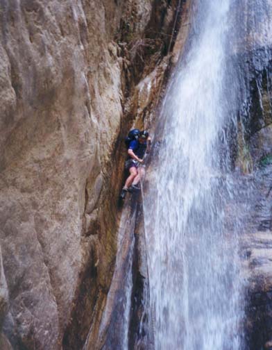
Back at the junction with Rubio Canyon and proceeding downstream, the walls of the canyon become ruggedly vertical and you enter the dramatic and exciting part of this adventure as the canyon drops precipitiously during its southward progress to the valley below. Just after the junction you must wade for the first time and, about 10yds further downstream, you come to a double waterfall comprising 15ft and 12ft drops with an inviting, large circular pool in between. This is the pool that Professor Lowe called Diana's Bath. A water pipe is suspended above you on the right and there is a shelf (spanned by the water pipe) on the right above the circular pool. There are several ways to descend the uppermost of these two falls. Perhaps the easiest is to climb up to the pipe and, using it, access the shelf on the right. Then you can either rappel using the pipe as a support or downclimb to the pool. The lower falls can be simply downclimbed at low water; alternatively you may continue your rappel to the bottom.
 | 
| |
|---|---|---|
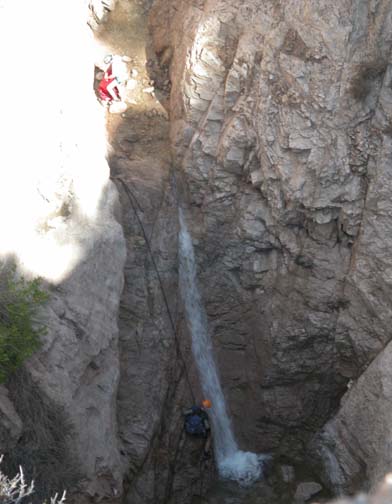
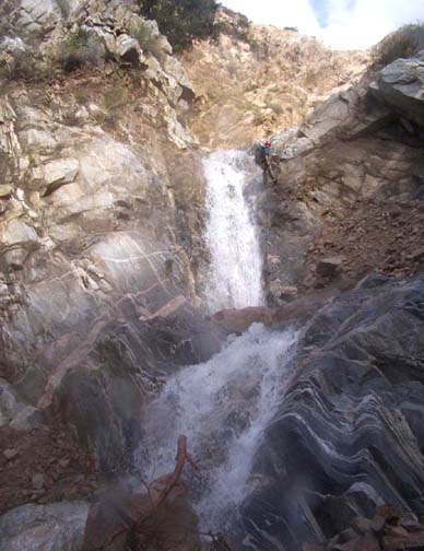
| Roaring Rift Falls from overhead (Photo by Robert Bowman) | Ribbon Rock and Moss Grotto Falls |
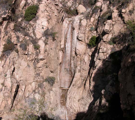
About 30 yds downstream you will arrive at the awesome Thalehaha Falls, that drop about 80ft vertically down into a narrow, rockribbed cleft When Professor Lowe's Rubio Pavilion was in its heyday at the turn of the century, the wooden walkways and staircases allowed tourists to come upstream all the way to this point at the base of Thalehaha Falls. In John Robinson's story of the San Gabriels there is a photograph of the Falls (which he calls Bridalveil Falls) with visitors perched on a wooden platform.
There are two possible routes for the descent of Thalehaha Falls. There is a good single bolt anchor on the right about 4ft above the lip; it could be backed up from a pipe embedded in the cliff about 5ft abobe the bolt. At low water this is a pleasant rappel with an easy entry. At higher water you will mostly be rappeling in the water. In either case it pays to stay to the right where there is a sheltered groove in the cliff face. The drier alternative is to use as anchor the tree about 15ft up the ridge on the left above the lip. This will take you down to a point a few yards downstream of the bottom of the falls.
Two smaller waterfalls follow immediately (they can be seen from the top of Thalehaha). The first, called Roaring Rift Falls, is about 20ft high; a good bolt has been installed in the rock on the right of the lip and allows you to rappel down the right of the falls. The second, called Suspended Boulder Falls, follows immediately and occurs where the canyon makes an abrupt right turn. [This can now be downclimbed though you may choose to rappel from a webbing wrap around one of several large boulders upstream of the falls.]
Another 40yds down canyon you will encounter the partial remains of a small dam that was built during the heyday of Rubio to create a small reservoir known as Mirror Lake. The dam forms the lip of a two stage waterfall called the Grand Chasm Falls with drops of 25ft and 45ft [now about 35ft]. There used to be a risky climbing trail up to a tree above the lip on the right that accesses a ledge from which it was relatively easy to climb down the scree slope to the bottom of these falls. Now you must rappel down both falls; for an anchor you can use a webbing wrap around one of several large boulders in mid-canyon. It is probably easiest to descend using two seperate rappels and a anchor around an old pipe on the intermediate platform.
About 30yds further you come to the last rappel down yet another beautiful, two-stage waterfall with drops of 20ft and 30ft. Professor Lowe gave separate names to the two parts of this waterfall and called them Ribbon Rock Falls and Moss Grotto Falls (another account suggests he named them for his wife and called them Leontine Falls). If you have had enough of rappelling at this point, you may choose to take the old, badly eroded trail to the bottom instead. This proceeds to the left from the lip of the falls and climbs a short way. I recommend that, instead of climbing down the dangerous slope at the first point where the trail has been washed out, you continue to travel horizontally past several badly eroded spots and contour into the gully down which it is easy to climb. This takes you to the bottom of falls. Otherwise, if you choose to rappel, there are several large rocks a short distance upstream of the lip that can used as anchors [note that it is no longer neccessary to rappel down what little remains of Moss Grotto Falls].
In the old days (and up until about 1980), there was a beautiful and deep circular pool on the shelf between Ribbon Rock Falls and Moss Grotto Falls. Then, some large winter storm deposited a huge boulder in this pool and ruined it. Fortunately, I swam in it before it was filled with the boulder. The wooden stairway proceeded up the left side of Moss Grotto Falls and visited the circular pool on the way.
Proceeding downstream from the bottom of Ribbon Rock/Moss Grotto Falls you cross the location of the old 15ft Maidenhair Falls now buried beneath the debris flow. Below this it is a short way to the location of Rubio Pavilion, identifiable by the large concrete foundation blocks that are all that now survive of that famous enterprise. At this point (34o12.32'N 118o7.04'W and elevation 1940ft) climb up the right wall at one of several points to access the trail along the roadbed of the old tramway up to Rubio Pavilion. This trail will take you out of the canyon to the trailhead; it is now washed out in a number of places but still allows a relatively easy exit to the point where you left the return vehicle (34o12.18'N 118o7.38'W and elevation 1820ft).
Extension in upper Rubio Canyon
Upstream of the point where the above hike descends into Rubio, there is a wooded stretch of canyon that makes for a pleasant extension of this adventure or, alternatively, for a much easier and shorter hike. To access this stretch, take the Castle Canyon trail from Echo Mountain (34o12.74'N 118o7.30'W and elevation 3200ft). This contours into upper Rubio Canyon and passes above the junction of Castle and Rubio Canyons. After 15min, you will reach the stream crossing in Rubio (34o13.10'N 118o7.10'W and elevation 3390ft). Leave the trail here and proceed down this small, wooded canyon. About 20min into this off-trail hike, you will arrive at the first of the two modest obstacles in this extension. This occurs at the junction of Rubio and Castle Canyons; both streams tumble over waterfalls just before they merge. The larger waterfall is in Rubio Canyon and makes for a nice rappel if you choose this means of descent. However, a fairly easy alternative that does not require ropes is to round the apex of the junction into Castle Canyon, and then cross to the other side of Castle where a steep earthy slope allows descent to the bottom.
Another 25min will bring you to the second modest obstacle, a 20ft waterfall that can be seen from Echo Mountain. This is easily circumvented on the left by using the pipe as a handhold and, a very short distance beyond, the canyon broadens and you will notice a substantial meadow above the stream on the left. This is the landmark by which to recognize the point where the main adventure descends into Rubio Canyon from Echo Mountain at 34o12.78'N 118o7.15'W and elevation 2850ft). The duration of this detour is about 1hr and so adds about 50min to the main hike.
The detour can be employed as an extension to the main hike or,
by directly ascending to Echo Mountain, as a short adventure hike.
In the latter case, the total duration beginning at the Lake Avenue
trailhead and returning there is 3hr 40min.
Last updated 1/1/05.
Christopher E. Brennen