ADVENTURE HIKES AND CANYONEERING
IN THE SAN GABRIELS
© Christopher Earls Brennen

|
|---|

|
Hike H5. Lower Cucamonga Canyon
- Hiking time: 1.5 hours
- Estimated hiking distance: 1.6 miles
- Elevation gain: None
- USGS Topo Maps: Cucamonga Peak
- Difficulties: One 50ft rappel, one small chute, some bouldering
- Special equipment: Rapelling equipment with 100ft rope
-
ACA Rating: 2B I

Characteristics
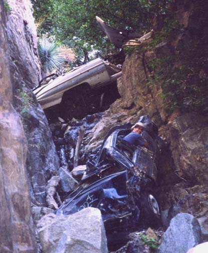
This is the second of three adventure hikes that, combined, explore the full length of Cucamonga Canyon, all the way from its origins in the shadow of Cucamonga Peak to the large wash that it has created in the valley below. It is a short hike with only two significant obstacles, a 50ft rappel that allows passage around an interesting waterfall and a small, awkward chute that leads to a necessary swim. The canyon itself is verdant and shady except for the last section down the open wash. Indeed it would be a very attractive short hike were it not for vandals who have scattered trash in many places and spray painted many of the rocks. The battered remains of many automobiles also litter the canyon, having apparently been jettisoned off the dirt road high above the east side.
Trailhead
This is a one way hike down and out of Cucamonga Canyon, starting at the point where the Middle Cucamonga Canyon hike ends. Though there are several ways to set up the hike, perhaps the easiest is a car shuttle using two four-wheel-drive vehicles.
The hike is accessed as described in the Middle Cucamonga Canyon hike. From the west and driving east on Foothill Boulevard, turn north on Euclid in the city of Upland, then right onto 19th Street and left (north) on Sapphire. At the northern end of Sapphire, turn left on Almond and go all the way to the end of Almond where there is a dirt parking area overlooking the Cucamonga wash (34o9.71'N 117o38.05'W, elevation 2220ft). A dirt road leads northward from this area into the wash but further vehicular progress is prevented by a locked gate. Park one vehicle here and then go back east on Almond and turn left (north) on Skyline. Skyline rapidly narrows to a single lane as it climbs into Cucamonga Canyon. It then turns into a rough dirt road for which four-wheel-drive is sometimes necessary. After about 0.3mi the dirt road forks; take the left fork that descends and crosses the river at a concrete ford just before a large clearing where there are many places to park (34o10.86'N 117o37.80'W, elevation 2680ft).
Hike
Proceeding downstream from the concrete ford, you can follow a use-trail that mostly proceeds along the left side of the river. The stream that joins from the right very shortly after the start comes down from the Frankish Peak off-road vehicle area. Then, just 10min from the start, the canyon suddenly narrows and the river crashes into a steep, narrow and winding gorge (34o10.76'N 117o37.78'W, elevation 2630ft), cascading into a large rock-walled pool that is hard to see from above. When we passed this way, kids had constructed a makeshift coffer dam from a tarp and logs in order to deepen the pool, presumably so they could jump into it. Our means of descent was much less dangerous; a rock ledge above the falls on the left leads to a place where you can rappel down 50ft to the bottom of this series of waterfalls. A stout iron shaft (complete with cog wheel) embedded in the rock at the end of the ledge provides a solid anchor for the rappel. Other ropes hang down from this anchor but it would not be wise to use them. Rockclimbers may notice the bolts and webbing installed in places in the rock wall to the right of the waterfall. Someone has clearly found good climbing here.
|
|---|
| Troy driving up canyon! |
A short way downstream (45min from the start) the canyon narrows again and you encounter a small and awkward chute descending into a deep pool. Usually there is a moderate stream flow in this canyon and the difficulty at this chute is to avoid being overwhelmed by this flow, strengthened by being funnelled into the chute. Here again there are several old ropes to aid in the descent (or ascent?) but I recommend locating a small bolt set in the rock at the top of the chute and using a rope or length of webbing around this bolt to control your descent. You will have to resign yourself to getting wet for the pool is deep and you will need to swim. There are no more major obstacles downstream of this point.
In several places you will have noticed the carcasses of automobiles that were dumped off the dirt road to crash down to the canyon bottom. The worst stretch of canyon, littered with about a dozen wrecks, occurs about 70min from the start and just upstream of the concrete remains of the gaging station (34o10.44'N 117o37.89'W, elevation 2450ft) that is marked on the topo map.
About 5min further downstream you arrive at the small dam that
directs most of the stream flow into a water supply conduit. You
circumvent the dam on the left where a dirt road begins and leads on
down the canyon. It is a simple matter to follow this road all the
way to the parking area where you parked the first vehicle
(34o9.71'N 117o38.05'W,
elevation 2220ft).
This you will reach about 1hr 30min from the start.
Last updated 7/30/99.
Christopher E. Brennen