ADVENTURE HIKES AND CANYONEERING
IN THE SAN GABRIELS
© Christopher Earls Brennen

|
|---|

|
Hike B7. Left Fork of Fusier Canyon
- Hiking time: 3.5 hours
- Estimated hiking distance: 3.4 miles
- Elevation gain: 1010 feet
- USGS Topo Maps: Condor Peak
- Difficulties: Two moderate rappels of about 50ft
- Special equipment: Rappelling equipment with 160ft rope, two rappel rings, 20ft webbing
-
ACA Rating: 3A II

Characteristics
This pleasant, short canyoneering adventure descends the left fork of Fusier Canyon from the Condor Peak Trail down to Big Tujunga Canyon Road. It is a short hike with just two rappels of about 50ft and could be done anytime of the year. Though hot and waterless in the summer there is sufficient shade to make it tolerable.
Note that this hike could be conveniently combined with a descent of the lower section of Fusier Canyon and thus make for a comfortable day of canyoneering.
Trailhead
This hike requires a short car shuttle or the placement of a bicycle for return to the start. First drive up Big Tujunga Canyon Road to the marked trailhead which is 0.9mi south of the bridge over the Big Tujunga just below the reservoir. This trailhead is at 34o16.96'N 118o12.61'W and an elevation of 2310ft. Leave either a return vehicle there or stash a bicycle for the return along the road after completion of the hike.
Then drive 1.3mi west along Big Tujunga Canyon Road to a point about 100yds east of the junction with the Vogel Flats Road. Park in a turnout out on the south side of the road at 34o17.23'N 118o13.47'W and an elevation of 2080ft.
Hike
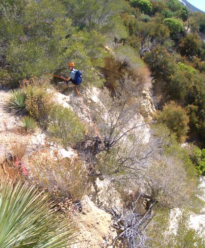
For such a substantial route, the start of the trail (known as the Vogel Flat Trail) is quite obscure. It is not marked on the topo map though other trail maps do feature it. But it is also hard to find where it starts. From the parked vehicle(s) just about 100yds east of the junction with the Vogel Flats Road (at 34o17.23'N 118o13.47'W and an elevation of 2080ft) cross to the north side of Big Tujunga Canyon Road and look for an entrance in the bushes via a shallow depression. This opening is close to a mile marker that reads 4.5. Once on the trail it is well-maintained and easy to follow. It climbs steeply to a junction 0.4mi from the start at 2250ft. Here the Vogel Flat Trail meets the Condor Peak Trail that begins where you parked the return vehicle. Turn left at the junction and continue up the Condor Peak Trail as it switchbacks up the ridge between Vogel and Fusier Canyons. Eventually, the trail reaches a notable and dramatic saddle overlooking the head of the left fork of Fusier Canyon at 34o17.89'N 118o12.79'W, an elevation of 3060ft and 2.2mi from the start. You should reach this drop-in point about 1hr after setting out.
 | 
| |
|---|---|---|
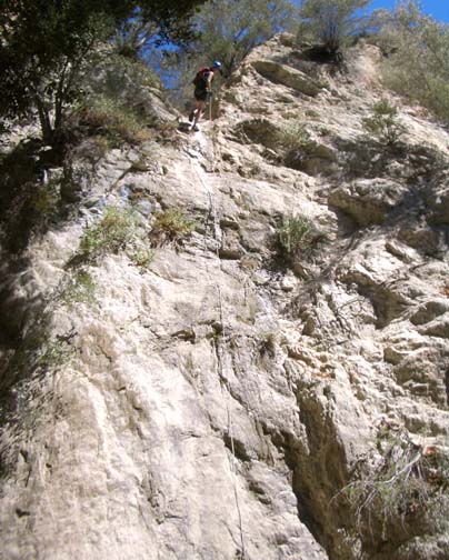
| Dropping into the Left Fork | Second rappel |
The drop-in to the Left Fork of Fusier Canyon represents the first of two rappels in this hike. For an anchor we used webbing around a bush on the far side of the saddle and descended about 45ft down a loose sandy slope into a steep wash. From there it is a steep and loose descent into the depths of the Left Fork with a little bushwhacking in places. After about 40min you will arrive at the top of the second rappel at an elevation of 2800ft. This is a clean, vertical 50ft drop which may have water flow in the winter but is dry in the summer. There are several small bush anchors on the right side but they need a human backup.
Downstream of this second rappel, the canyon flattens out and there is more shady foliage. At 2380ft and 2hr 45min from the start you should come to two small 10ft downclimbs one after the other, followed immediately by the confluence with the main fork of Fusier Canyon that comes in on the left. This confluence at 34o17.49'N 118o12.62'W is about 2.6mi and 2hr 50min from the start. Note that there is a 18ft dryfall just a few yards up the main fork from the confluence.
Downstream of the confluence the canyon is broader and shadier with a little
water in places and some very pretty groves. A large branch enters on the
left at 2310ft and there is a nice dryfall on the right at
2240ft. Finally after several sharp canyon turns you will encounter
the steel structure that is all that remains of an old road bridge and just
beyond it the tunnel that carries the runoff in Fusier under the Big
Tujunga Canyon Road. Turn right before the entrance and the use trail will
take you up to the road. You should reach this point
at 34o17.04'N 118o12.50'W and
an elevation of 2230ft about 3.5hrs and 3.4mi from
the start. The trailhead where you left the return vehicle (or stashed the
bicycle) is just about 100yds up the road to the west.
Last updated 7/30/06.
Christopher E. Brennen