ADVENTURE HIKES AND CANYONEERING
IN THE SAN GABRIELS
© Christopher Earls Brennen

|
|---|

|
Hike B13. Josephine Creek
- Hiking time: 3 hours
- Estimated hiking distance: 1.1 miles
- Elevation gain: 670 feet
- USGS Topo Maps: Condor Peak
- Difficulties: Two rappels of 60ft and 180ft
- Special equipment: Rappelling gear with 200ft rope, 200ft pull cord, 20ft of webbing, 3 rappel rings
-
ACA Rating: 3A II

Characteristics
Josephine Creek is a pretty, short canyon with one awesome 180ft rappel and a smaller 60ft rappel. It is a verdant north-facing canyon with lots of shade for a warm summer day and decorated with ferns and other foliage. Frequently there is a small water flow that can be most refreshing. The hike back up to the highway follows a fairly well-travelled trail. The entire hike should only take about 3hrs and could be suitable for any time of the year. It might be a good choice for intermediate canyoneers wanting to try a big drop.
Trailhead
The trailhead for this hike is a dirt parking area (at 34o17.84'N 118o10.44'W and elevation 2910ft) on the inside of a long curve on Big Tujunga Canyon Road, 1.0mi west of the junction with the Angeles Forest Highway. This is a big long dirt area with room for many vehicles.
Hike
From the parking area (34o17.84'N 118o10.44'W) hike south along the road to where the road crosses the creek (at 34o17.70'N 118o10.42'W), and drop down into the canyon by descending the overgrown scree slope. You quickly reach the wooded canyon bottom and it is easy going for a few hundred yards until, at 2720ft and 25min from the start you come to the top of the first significant obstacle, a vertical drop of 25ft. You can either rappel this drop using a bush in midstream as anchor or you can negotiate a somewhat slippery downclimb around to the right hand side. Climb over the bluff on the right and then choose one of several slippery descent routes.
 | 
| |
|---|---|---|
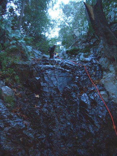
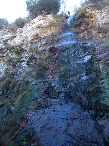
| Josephine Creek 60ft rappel | Josephine Creek 180ft rappel (Photo by Ira Lewis) |
More easy canyon follows before you arrive at the first required rappel (elevation about 2640ft), a 60ft sloping waterfall using a solid tree anchor in midcanyon. You should reach this point about 50min from the start. The canyon here is a beautiful shady glen replete with ferns and foliage. Water is frequently flowing here. Just a few minutes below this rappel you will come upon a steep side-gully on the left where several vehicles have been dumped from the parking lot where you left your vehicle. Thus the canyon bottom is littered with tires and other automobile parts. Below this point the canyon becomes a little more challenging with narrow places where you may have a thigh-deep wade or two.
|
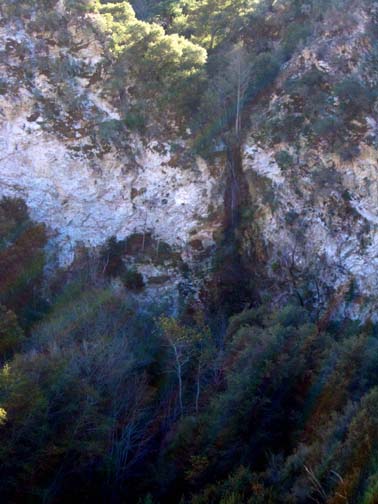
|---|
| Big rappel from exit trail |
Then, suddenly, the canyon explodes and, at an elevation of 2480ft and 1hr 40min from the start, you are standing at the top of a 200ft cliff that forms the edge of the Big Tujunga. Here the big canyon makes a sweeping right hand turn that Josephine Creek enters on the outside apex. Thus the Big Tujunga forms a great amphitheater below you. It is an exhilerating 180ft vertical rappel descent to the base of this cliff. There is a solid tree anchor toward the right side of the lip that leads to a rappel down alongside the dribbling stream (if there is one). Then it is an easy hike following the streambed down to the Big Tujunga and the edge of Mill Creek (the river that runs through Big Tujunga). You should reach Mill Creek (at 34o18.02'N 118o10.41'W and elevation 2230ft) about 2hr 20min from the start.
Immediately upon encountering Mill Creek, look to the left and you should see
the steep, sloping start to the trail that takes you back up to the road.
The lower section of this trail is badly eroded and a little hard to
find in places. However, as you ascend, it becomes more established (though
somewhat overgrown) and switchbacks up to the top of a ridge that protrudes
out into the Big Tujunga. Once you reach the ridgetop you contour back to
a point just below the highway. At the highway turn left and hike eastwards
back to your vehicle, a distance of just a few hundred yards. The whole hike
should only take about 3hrs.
Last updated 12/4/05.
Christopher E. Brennen