ADVENTURE HIKES AND CANYONEERING
IN THE SAN GABRIELS
© Christopher Earls Brennen

|
|---|

|
Hike G3. Iron Mountain
- Hiking time: 11 hours
- Estimated hiking distance: 15 miles
- Elevation gain: 6000 feet
- USGS Topo Maps: Mount San Antonio, Mt. Baldy, Glendora
- Difficulties: Some steep, rocky slopes
- Special equipment: None needed
-
ACA Rating: 1A IV

Characteristics
This is a hike that is more of a challenge to your endurance than anything else. Your reward is the satisfaction of conquering the toughest peak in the San Gabriels and the magnificient and dramatic views from the summit.
It may be possible to climb Iron Mountain in one day though this would require a very early start and a late finish. From the ridge that the Heaton Flats Trail (8W16) follows, the mountain looks deceptively close and it is hard to believe that it could take more than a day to reach the summit and return. In fact, it is a very hard (and waterless) climb. John Robinson has characterized it as the toughest peak in the San Gabriels to reach and my own experience confirmed this. The most important thing to ensure is that you take sufficient water for there is none available anywhere once you leave the East Fork. I recommend at least four quarts per person. Moreover, there is little shade so that the hike is very difficult in warmer weather. Choose a cool spring or fall weekend.
Trailhead
The trailhead of this hike is the same as that for the Allison Mine hike, namely the parking area at the end of the road up the East Fork of the San Gabriel River (34o14.21'N 117o45.92'W, elevation 2030ft). This is about a half hour drive up Highway 39 from Azusa with a right turn across the bridge and up the East Fork road to its terminus.
Hike
The first part of the climb is the same as the Allison Mine hike. You proceed up the East Fork about 0.5mi to Heaton Flats (34o14.48'N 117o45.68'W, elevation 2050ft) and then turn right onto the Heaton Flats trail that climbs up a steep side canyon. This reaches a saddle where the trail turns left and proceeds to the top of a ridge. Follow the trail along this ridge with a number of ascents and descents until you reach a notable saddle at a distance of 3.8mi from the start, at 34o15.53'N 117o43.38'W and an elevation of 4580ft; this takes about 2hr 30min. I recommend this saddle for an overnight stop. There are some pleasant flat places to camp and some brush to provide shelter from the wind. When I climbed the mountain, I hid my overnight equipment here in the bushes and retrieved it during my descent.
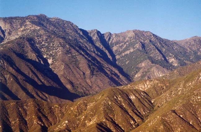
|
|---|
| Iron Mountain (left) from the Glendora Ridge road |
This saddle has three other trails that emanate from it, some in better condition than others. As described in the Allison Mine Loop, the best maintained trail descends to the right or east to Widman Ranch and Coldwater Canyon. A very rough trail contours off to the left or west of the saddle on its way to the Allison Mine. Our route lies directly ahead straight up the steep slope on the north side of the saddle. At this point the hike begins to look much more difficult but, again, appearances are deceptive. In fact, though there are other steep sections requiring some scrambling, the trail to the top of Iron Mountain is in much better shape than might be expected from other descriptions. In 1995 when I made the hike it seemed as though some group had made a substantial effort to clear and maintain long stretches of the trail.
Once the initial climb up from the saddle has been accomplished the trail follows another ridge with three or four minor peaks on it. The vegetation on this section is bush and scrub with some trees. It is fortunate that long sections have been cleared for it would otherwise be a much more difficult hike with lots of bushwhacking. Gradually the vegetation changes as one rises until you emerge on a more consistent open slope with scattered pine trees. Along this stretch, there is a precipitous drop to the left down into the canyon cut into the side of the mountain by Allison Gulch. To the right the land in the foreground is less dramatic but further in the distance it rises dramatically to the ridge running from the summit of Iron Mountain all the way to the top of Mount San Antonio (commonly known as Mount Baldy). This ridge is called the San Antonio Ridge.
About 3hr 30min after leaving the saddle, you finally reach the last section of rocky trail leading to the 8007ft summit of Iron Mountain (34o17.30'N 117o42.80'W). The peak itself is a little strange for it comprises a rectangular area about 20ft by 30ft that someone has flattened and mostly cleared of rocks. Perhaps some group likes to camp there even though it is quite exposed. There is a logbook stored in a cairn in the center and you should be proud to enter your name for it is a significant achievement to reach this peak.
However, what will really hold your attention is the magnificient view (provided, of course, you are reasonably fortunate with the weather). The land drops off precipitously in almost all directions. To the west is the great gorge of the East Fork; the Narrows, described in the East Fork Transit, lie some 6000ft below you. To the north the wild canyon of the Fish Fork runs westwards from the slopes of Baldy to mix with the waters of the East Fork. To the south are the cliffs above Allison Gulch and the steep but shallow ridge we used to reach the summit. But perhaps the most dramatic features are to be seen to the east where the bulk of Mount Baldy dominates the background. San Antonio Ridge can now be seen winding its way down from the West Baldy summit to where you stand on Iron Mountain. And, if you walk downhill a little way in an easterly direction, you will begin to discern the notches that present the principle obstacles for the hike along the ridge from one summit to the other.
But, on this hike, we are destined to return by the way which we came.
The hike back to the trailhead
(34o14.21'N 117o45.92'W,
elevation 2030ft) is very long indeed
(about 4hr 30min)
and the cool waters
of the East Fork are very inviting when you reach Heaton Flats again.
Last updated 7/30/99.
Christopher E. Brennen