ADVENTURE HIKES AND CANYONEERING
IN THE SAN GABRIELS
© Christopher Earls Brennen

|
|---|

|
Hike D12. Hastings Canyon
- Hiking time: 7 hours
- Estimated hiking distance: 3.5 miles
- Elevation gain: 1930 feet
- USGS Topo Maps: Mount Wilson
- Difficulties: About 12 rappels ranging in height from 20ft to 70ft, some bushwhacking.
- Special equipment: Full rappelling equipment with a 160ft rope, a 120ft rope, 150ft of webbing, 12 rappel rings.
-
ACA Rating: 3A III

Characteristics
Hastings Canyon is a rugged fissure in the front range of the San Gabriel mountains just north of Sierra Madre. Like its neighbours, Pasadena Glen and Bailey Canyon, this canyon contains a long series of substantial drops that require about a dozen rappels. It is very rarely visited because access at the bottom in restricted by the local water district. Moreover, it is not easy to access from the top either; here we describe an access route that requires some bushwhacking and some navigation. Despite these difficulties the canyon is a real gem and relatively brush free.
Though it should be avoided during or shortly after heavy rain, the canyon drains fairly quickly and, even in winter, it is mostly quite dry. Too hot in summer, this is a good trip for fall, winter or spring.
Trailhead
This adventure requires a short car shuttle. First drive to the exit point at the end of Hastings Canyon. Drive north on Michillinda Avenue on the border between Pasadena and Sierra Madre. Veer left onto Startouch Drive at the end of Michillinda, and almost immediately fork right onto Carriage House Road and then turn left onto Ranch Top Road. Continue along Ranch Top Road and just about 100yds after crossing Hastings Ranch Drive the road crosses the culvert that exits Hastings Canyon (at 34o10.51'N 118o4.37'W and elevation 1350ft). Park a recovery vehicle here and then drive back down Michillinda Avenue. Turn left onto Grandview Avenue and then left again onto Grove Street. Grove Street ends at the Bailey Canyon parking lot (34o10.26'N 118o3.67'W and elevation 1120ft). Park here.
Hike
From the parking area (34o10.26'N 118o3.67'W and elevation 1120ft), walk WNW through the trees, go through a turnstile and proceed north on the closed asphalt road that skirts around the west side of Bailey Canyon debris basin. The asphalt changes to dirt as you enter the canyon and quickly becomes a trail. About 0.25mi from the parking area, the trail crosses the stream bed for the first time and, immediately thereafter, you come to a trail fork (34o10.57'N 118o3.68'W and elevation 1350ft). Follow the right fork that switchbacks up the right or east wall of the canyon to an elevation of about 2000ft and then contours north to drop into a lovely little glade perched in a pocket high above the cliffs and waterfalls of the lower canyon. Years ago, someone carried sufficient building materials up the steep trail to construct a small stone cabin. Now, only low stone walls remain to serve as a bench or table at this delightful picnic venue. You should reach this rest stop (at 34o11.10'N 118o3.55'W and an elevation of 2400ft) about 1hr 15min from the start.
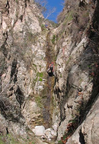 | 
| |
|---|---|---|
| 60ft rappel in the Hastings slot | Eighth rappel in Hastings Canyon |
From the Stone Cabin drop down into the Bailey Canyon wash and hike upstream, almost immediately forking left. Continue up this left fork until you arrive at a 15ft waterfall that blocks easy passage. Go back down canyon about 50yds to about 34o11.16'N 118o3.60'W and an elevation of 2550ft) and follow a faint use-trail up the ridge on the left or southwest side of the canyon. Follow the slight and sometimes non-existent use-trail on the apex of this lateral ridge all the way up to the main ridgetop seperating Bailey and Hastings Canyons. This 450ft cross-country climb requires some bushwhacking and the use-trail disappears in places. You should reach the ridgetop (elevation 3030ft) about 2hrs after starting out.
There is a good trail along the ridgetop (indeed an alternate route to this point would be to access the ridgetop just north of the mission or a few hundred yards north of the Bailey Canyon trailhead and to follow the ridge all the way up.) From the point where you reached the ridgetop, turn right and hike north along the ridge while surveying the topology on the Hastings Canyon side. Hike several hundred yards to a shallow saddle just before the ridgetop begins to climb steeply. At this point you should see a deep gully in the Hastings watershed just a short way down a steep brushy slope. This is the drop in point at 34o11.26'N 118o3.78'W and an elevation of 3120ft. Leave the ridgetop here and head down the steep slope. By careful route finding and some bushwhacking you should be able to find a route down into the deep gully about 200ft below the ridgetop. Care is needed here to avoid cliffing out and/or sliding out of control down the steep, loose slope. You should reach the gully bottom (elevation 2890ft) about 2hr 40min from the start.
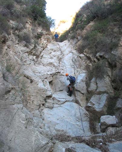
As you begin your descent of Hastings Canyon, this steep gully is relatively free of brush but you soon encounter a number of short downclimbs where some may need a belay line. There is a 20ft downclimb at 2640ft after which a large tributary comes in on the right. Two more 20ft downclimbs are encountered before you arrive at the first rappel at an elevation of 2460ft. You should reach this point about 4hrs after starting out. The first rappel is a 30ft descent from a tree anchor on the left and takes you down past two huge, canyon-blocking chockstones.
Shortly after this first rappel the canyon narrows almost to a slot and there are four rappels in rapid succession as you drop down through these narrows. The first of these rappels is a drop of about 50ft down a sloping slot using a small tree anchor up a steep gully on the left. This is immediately followed by a vertical 20ft drop that can be anchored by a tree on the left a little ways back from the lip. Then, after a short stretch of downclimbing (still in the slot) you arrive at the top of a spectacular 60ft vertical drop. This is anchored by a webbing wrap around a midstream boulder. The slot opens up below this rappel and a short distance downstream, at an elevation of 2190ft, there is a short but vertical 25ft rappel that we anchored from a small bush on the left (a better anchor needs to be found here). Just beyond this a large tributary canyon enters on the right at 2150ft.
Immediately below this junction there are two dryfalls that require rappels. The first of these is a 30ft multistep rappel from a tree on the right; some may choose to downclimb this. It is immediately followed by a 35ft rappel down a broad dryfall; the only obvious anchor is a a tree on a sloping ledge off to the left of the lip; access to this tree is a little exposed; it requires a belay and a length of line to retrieve the rope after each descent. After this the gradient in the canyon begins to decrease and there is a short hike to the next rappel.
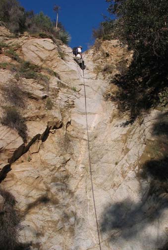
|
|---|
| Ninth rappel in Hastings Canyon |
You should reach the next rappel (elevation 1880ft) about 6hrs after the morning start. Here the streambed flows through a narrow gate and drops vertically about 60ft. The rock here is white and hard. The only convenient anchor is a small tree high up on the left side of the canyon near the lip. It is not easy to reach this tree and a human ladder may be neccessary. Shortly after this is a 40ft rappel from a tree high but accessible on the right side. It descends two big steps and has a very cute rock projection or seat sticking out of the second step that makes for a good photo opportunity. Here in the lower part of Hastings Canyon, the streambed in between rappels is often quite sandy and flat, making for easy hiking. Seperated by sections of such sandy bottom you will next encounter two short 20ft rappels, each anchored by trees on the left. And then, finally you arrive at the last rappel, a very nice vertical 60ft drop with a smaller step at the top. This rappel, at an elevation of 1580ft, is anchored by a tree on the right side of the canyon.
More sandy bottom follows before the canyon narrows for the last time and
in these narrows you quite unexpectedly encounter a gushing spring on the
right side of the canyon. This water supply abruptly changes the character
of the canyon which is verdant from here downstream. In the immediate
vicinity of the spring there is a dense bamboo forest and further downstream,
as the canyon broadens, you should follow the faint use-trail a short way up
the right side in order to avoid the dense thicket around the small
stream. Follow this use trail across grassy benches on the right until
you see
the concrete and stone embankment on the other, left side. Follow the
use-trail that crosses to and climbs this embankment. Hike down the road
and climb the fence in the far left corner to access Ranch Top Road
and your parked vehicle
(34o10.51'N 118o4.37'W and
elevation 1350ft). The total hiking time
should be around 7 hrs during which you will travel about
3.5mi.
Last updated 12/12/04.
Christopher E. Brennen