ADVENTURE HIKES AND CANYONEERING
IN THE SAN GABRIELS
© Christopher Earls Brennen

|
|---|

|
Hike B11. Great Falls of the Fox
- Hiking time: 11 hours (plus 2 hours with hike in)
- Estimated hiking distance: 4.5 miles (plus 5.7 miles with hike in)
- Elevation gain: 580 feet (and 1600 feet with hike in)
- USGS Topo Maps: Condor Peak
- Difficulties: One 100ft, four 30-65ft and three 12-20ft rappels, many into water over 6ft deep; much bushwhacking, bouldering and wading
- Special equipment: Rappelling gear with two 150ft ropes, 150ft cord, 150ft webbing, 8 rappel rings and dry bags
-
ACA Rating: 3BR IV

Characteristics
This difficult but spectacular adventure takes you down the Great Falls of the Fox, the most awesome in the San Gabriel mountains. If you completed an easier hike in this same series, Lower Fox Canyon, you will have looked up at the Great Falls from below and will have tasted this adventure. In my opinion, the Great Falls of the Fox provide the most exciting adventure hike in this book.
Fox Creek collects itself on the slopes of Mount Gleason and, from there, flows south and east to enter Big Tujunga Canyon just a little distance upstream of the Big Tujunga reservoir. About a mile upstream of this junction just as it rounds the base of Fox Peak, the creek hits a mass of hard granite and has cut a deep and narrow passage through that rock. As it does so it falls dramatically through the series of seven waterfalls that we call the Great Falls of the Fox. All are contained within a short section of gorge with towering cliffs on all sides. Once you enter this gorge there is virtually no option but to rappel on down to the bottom, and that includes an awesome descent of the 100ft Great Falls.
This hike should really be a two-day affair and is recommended as such. However, this necessitates carrying a heavy pack through some very rugged terrain. On the other hand it is possible, travelling light, to complete the adventure in one long day. To do so, it would be wise to start down the trail at dawn. In fact, when we did the hike described here, we were very fortunate to be able to arrange vehicular transport along the fire road from the trailhead to the water tank saddle, a distance of 5.7mi. Not only did this mean a savings in time of nearly two hours but it also yielded a substantial savings of energy. This truck ride is reflected in the first estimates of time and distance given in the list above.
Clearly this adventure is only for the highly experienced rappeller. Moreover, it should only be attempted when the water flow is at its minimum. After any significant rainfall, it would be almost impossible (and very dangerous) to attempt to negotiate the central section that includes the Great Falls. Moreover, I strongly recommend you choose a hot summer day for you will be soaking wet for a large fraction of the time and, in the shade of the deep central canyon, you can get very cold (unless you wear a wetsuit). For the same reason another, almost essential, piece of equipment for this hike is a large, tough waterproof bag in which to stow your pack.
But any who do complete this hike will be treated to a spectacular gorge and will remember it as a truly great adventure.
Trailhead
The trailhead for this hike is the same as for the Lower Fox Canyon hike, namely the dirt parking area (at 34o17.82'N 118o10.20'W and elevation 3090ft) by a locked gate on Big Tujunga Canyon Road, 0.5mi southwest of the junction with the Angeles Forest Highway.
Hike
The first part of the hike is identical to that of the Lower Fox Canyon adventure, namely a walk down into Big Tujunga along the Fall Creek Fire Road, across the river (at 34o18.31'N 118o9.61'W) and up the road as it climbs the other side of the canyon. In this main section we describe the longer route to the head of the gorge because this is the route that is most easily found and most easily described. However, there is a shortcut to the head of the gorge which we will describe as an addendum. It cuts almost two hours off the time given in the main section but is not recommended because it is a difficult, overland route that is not easy to follow.
The longer route proceeds up the fire road past the point where you left the road on the Lower Fox Canyon hike. Indeed, you must hike another 2.2mi up the road to a prominent saddle (at 34o19.66'N 118o10.23'W and elevation 4000ft) on which there is a large water tank. This large, round structure with a flat concrete roof is typical of the many water tanks in the San Gabriels and is readily identified. However, some distance before the water tank, you will pass another prominent saddle (about 4.1mi from the start and at an elevation of 3280ft) with a marvellous but distant view of the Great Falls of the Fox. For this reason we call it Falls View Saddle. Here, on a winter's day with the river flowing full you can hear the roar of the falls from about half a mile away. This should spur you on to cover the remaining rather dull 1.6mi to the water tank saddle, which you should reach about 2hr from the start.
At the water tank saddle it would be wise to dress in long sleeves and pants (or gaiters) for the next part of the hike requires much bushwhacking. First you must drop down a small, steep gully into the canyon to the west of the saddle. We chose the gully immediately below the road. After a drop of about 250ft you reach the bottom of this unnamed canyon that, for good reason, we called Bramble Canyon. It proceeds in a generally southwest direction; the bottom alternates between relatively open going and stretches that are quite overgrown with brush. Thin, skin-tearing brambles make some sections particularly unpleasant; we also noted clear signs of bear.
After about 45min of travel in Bramble Canyon (and at an elevation of about 3600ft), you will reach the only substantial obstacle in Bramble, namely a large dryfall after which the canyon turns sharply right. A use-trail seems to climb to the left and your first inclination is to proceed in this direction. But it is much better to follow the use-trail on the right that surmounts a small bluff, turns the corner and then encounters a steep but readily negotiable draw that you can descend all the way to the canyon bottom below the falls.
About 2hrs 15min after leaving the water tank saddle, the junction of Bramble Canyon and Fox Canyon (at 34o19.11'N 118o10.97'W and elevation 3160ft) is finally reached. I recommend you leave a duck here to use in recognizing the junction should you need to return this way. Then turn right and proceed down Fox Canyon. Here the stream flows year-round and therefore the canyon is heavily wooded. The going is much better than in Bramble Canyon but still not fast; much boulder hopping and lots of fallen trees and branches. Finally, 3hrs 15min from water tank saddle (5hrs 15min from the trailhead if you hiked the fire road) you reach the feature you came to see, the gorge of the Great Falls of the Fox.
 | 
| |
|---|---|---|
| First and second rappel | Third rappel |
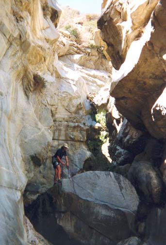
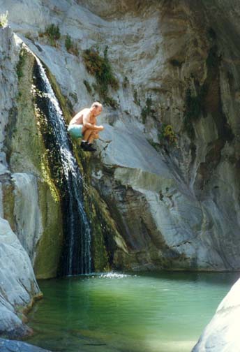
A small precursor tells you that you are almost there. This is a short chute through some solid rock into several sculpted pools about 5ft deep. It is a simple matter to wedge your way down this chute and wade through the pools. About 50yds downstream, at an elevation of 2960ft, you arrive at the top of the gorge of the Great Falls of the Fox (34o18.72'N 118o10.77'W). The canyon suddenly drops about 40ft into a chasm with solid, vertical walls of granite. The lip of the canyon bottom consists of huge boulders and, from this viewpoint, you can see a second, small 12ft waterfall downstream of the first. However, the canyon then turns to the left and what lies beyond cannot be seen.
The large boulders at the top of the first falls provide excellent and numerous anchors. There is a convenient platform on the right where the boulder forming the lip allows a convenient rappel entry next to the canyon wall. There is also a foothold on the far side of this boulder that is helpful. The rappel entry is nevertheless a little awkward because of the underhang of this rock just below the foothold. However, after the first 10ft or so, the remainder of the 40ft rappel is straightforward. You will descend into a deep pool from which you may need to swim ashore. The second, small waterfall, about 12ft high, also requires rappelling. There is a large rock on the left that makes for a good anchor and a convenient entry.
The third falls are immediately downstream of the second and involve a vertical drop of about 30ft. A large rock in midstream a short distance upstream of the lip provides a good anchor with a convenient rappel entry down a small slot on the right. Care is however necessary to prevent the rope from becoming wedged in this slot and causing a difficult rope retrieval. Again you descend into a deep pool that may require swimming.
The canyon opens up a little at this point and so it is a good place to catch some sun, to warm up and to get one's breath back. The gorge you have descended is an awesome sight above you so you should take time to enjoy it before the major challenge ahead.
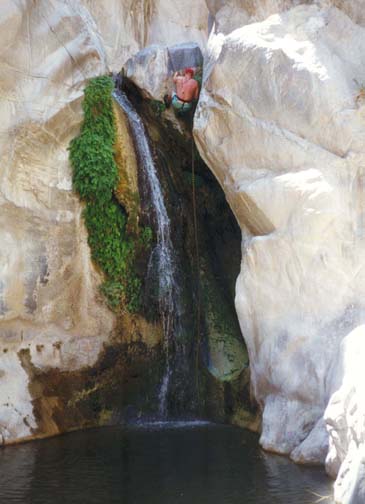
The fourth falls are a short distance from the third. They consist of a small 10ft vertical drop after a short, easily walked chute. Unfortunately there is no easy anchor here. Some might choose to jump the 10ft into a pool that is sometimes deep enough, though at other times only thigh deep. On one transit, the two young people I was with held the rope around the rock while I rappelled. Then they threw down the rope and jumped. On another occasion, the pool was too shallow and we devised a makeshift anchor using a piton in a crack in the rock wall on the right side. There is a large boulder in the middle of the pool below these fourth falls and allowed us to identify this location in some aerial photographs.
 | 
| |
|---|---|---|
| Great Falls of the Fox | Great Falls in the spring |
This first series of four waterfalls will take about 2hrs and should be completed about 5hrs 15min after leaving the water tank saddle (7hrs 15min from the trailhead if you hiked the fire road). Note, however, that the time taken for each rappel will vary greatly with the number and experience of the people in your party.
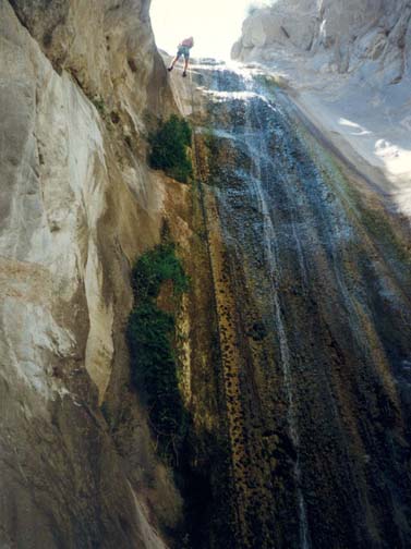
Downstream of the fourth falls there are two small pools and then a short flat section with trees and bushes. These terminate in a jumble of large rocks, logs and branches that mark the top of the big, 100ft waterfall. The lip curves gradually over and so it is not easy to get a view over the falls and down into the grotto and pool that lie at the bottom. However, just a glimpse is enough to set the heart pounding. Moreover, other factors conspire to add to the feeling of adversity. Perhaps because of the natural funnel in the topography at this point, there is often a stiff wind that blows over the top of the Great Falls and nowhere else. Moreover, this wind tends to blow spray up the falls and over those who would dare to approach. On the plus side there are plenty of large rocks to use as anchors and it is best to set up the rope on the right hand side which provides a relatively dry descent at least at low flows.
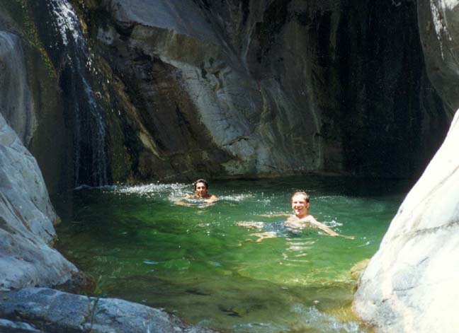
Aside from the awe-inspiring height and the magnified problems of rope retrieval, this is a straightforward rappel during low stream flow. It has a gradual and easy entry with a flat but fairly rough vertical surface for most of the way. And the pool at the bottom can be waded. But, having seen it from below during higher flow rates, I know it is very different when the water is bouncing off all the walls and you must descend through that liquid environment. Even at low flows, the rappel is a spectacular experience so take time to look around and enjoy the surroundings as you descend between vertical granite walls. The grotto at the bottom adds much to the aura of the place. With awesome towering cliffs on all sides and only a narrow opening to the sky, the bottom is almost all pool (mostly quite shallow). On one side the falls have eroded away the wall so that there is a substantial undercut or cave that enhances the enclosed feeling.
 | 
| |
|---|---|---|
| Jumping the sixth falls | Pool below sixth falls |
Rope retrieval after the descent of the Great Falls can be a problem for it is hindered by two factors. First, the sheer weight of 100ft of rope makes it difficult to pull it down; and, second, the curved lip at the top adds significantly to the frictional resistance. When setting up the rope you should try and place the rappel ring as far over this lip as you feel comfortable with during rappel entry. We used two climbing ropes tied together at the top so that we could employ a double-strand rappel. The alternative is to use a retrieval cord and a single-strand rappel but this could make the retrieval harder. If you are having difficulty, a potentially useful trick is to have one member of the party send waves up the main, up-going rope while all the others pull on the retrieval cord or rope. It would also be wise to keep one rope in reserve for the rappels further downstream just in case you cannot retrieve the rope at the Great Falls.
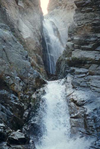
Immediately downstream of the Great Falls and deep within this narrow defile is a beautiful little waterfall about 20ft high that cascades into a magnificient pool again partly covered by overhang. One one passage this pool was deep enough to allow several of our party to jump the falls into the pool. On another transit the pool was too shallow. In either case I recommend descending by rappelling to the right of the waterfalls. There is no natural anchor, but fortunately three anchor bolts have been placed on the rock shelf just above this route. We replaced the webbing and used these bolts. I recommend you do the same though the anchor bolts could become unsafe at any time in the future and should be carefully tested. An alternative here would be to arrange a hook for the slot in the rock just over the edge of the shelf. This seems a good point at which to emphasize that anchors may change significantly as a result of winter storm floods. For this reason, it might be wise to carry a bolt kit with you on this hike.
You should arrive at this point about 6hrs 30min after leaving the water tank saddle (8hrs 30min from the trailhead if you hiked the fire road). On a warm day, this pool is worth pausing for - and swimming in. There is a low shelf just beside the waterfall that is readily accessible from below and allows a much less frightening jump than that from above. And the sun often penetrates an area just downstream of the pool if you need to warm up.
|
|---|
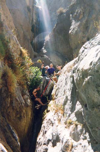
| Gathering above seventh falls |
The seventh and last of the waterfalls in the central gorge is straightforward but somewhat blind. Those who completed the lower Fox Canyon hike will benefit from having seen it from below. The anchor is a webbing wrap around a large rock wedged in the V-shaped canyon just downstream of the sixth falls. The webbing should be replaced, an awkward task since you must reach down over the rock. The anchor rock is about 30ft back from the lip of the falls. Between it and the lip is a narrow V-shaped slot with a mostly horizontal, water-filled bottom. The best strategy is to set up the anchor, rappel ring and rope (a double-stranded rappel with a 180ft rope or a single-stranded rappel with 100ft rope and retrieval cord) while above the anchor rock. Then one member of the party should climb down into the slot and supervise the rappel from the lip. The rappel below the lip is an easy 35ft descent with a shelf about midway; it ends in a broad, shallow pool.
Here, 7hr from the water tank saddle at 34o18.78'N 118o10.69'W and an elevation of 2650ft, you have emerged from the gorge into a broad canyon that the sun reaches more readily. It is good place to rest, warm up and change to a hiking mode. And the view of the Great Falls from below presents an awesome spectacle that engenders a real feeling of accomplishment.
The rest of the hike was described in detail in the Lower Fox Canyon adventure. There are a few minor obstacles to overcome just downstream of the exit pool but otherwise the going is fairly easy though it requires much wading and a little scrambling. This is a quiet, bucolic and attractive stretch of canyon. It takes about 1.5hr to reach the large exit falls, the eighth and final rappel in this adventure.
The Lower Fox Falls at the exit of Fox Canyon (34o18.24'N 118o10.70'W and elevation 2300ft) come upon you quite abruptly just as it seems you are about to reach the junction with Big Tujunga Canyon. From above they are an impressive sight as they plunge 65ft down a vertical cliff into a deep pool. There is virtually no way to travel up canyon past this obstacle unless you are an expert rock climber. Fortunately for those descending, there are two large trees about 15ft back from the edge that are ideally placed to serve as anchors. The rappel down the vertical cliff to the left of the falls is straightforward and has a moderately easy entry. You descend into a large pool that can vary greatly in depth from year to year. When we first did the easier Lower Fox Canyon hike it was was well over 6ft deep and we had to swim about 15yds before we could wade. On the other hand, a couple of years later when we first did the Great Falls hike it was only necessary to swim about 2yds back from the wall before you could stand on a sand bank.
Downstream of the Lower Falls, you should follow the use-trail along the large benches on either side of the canyon. The trail switches sides several times and it only takes about 10min to reach the junction with Big Tujunga Canyon (34o18.11'N 118o10.60'W), recognizable by its broad gravel-flat bottom. The two options for the hike back from this junction to Big Tujunga Canyon Road are fully described in the Lower Fox Canyon hike and will not be repeated here. You should reach your vehicle (at 34o17.82'N 118o10.20'W and elevation 3090ft) about 11hr after leaving the water tank saddle (or 13hr after leaving the trailhead if you hiked the fire road).
Difficult Cross-Country Approach:
We also describe here a difficult cross-country shortcut that accesses the head of the gorge of the Great Falls of the Fox. This shortcut cuts about two hours off the duration of the hike but is not easy to find. We note, however, that increased use in recent years has made this route easier to follow than in the past.
You begin the cross-country route by following the route of the Lower
Fox Canyon hike down to the Fox river below the gorge.
At the point where you reach the Fox
(34o18.67'N 118o10.53'W)
turn left and travel downstream for
about 100yds while taking note of the terrain above the canyon
on your right. You need to locate a small, brush-filled gully (with lots
of poison oak) that climbs out of the canyon on the right
at about 34o18.63'N 118o10.62'W; it occurs just
before the canyon makes a sharp left turn. You should also be able to
discern a rock and scree slope up on the left just downstream of the
sought-after gully. Head up the gully through the poison oak and after a short
way you will see a use-trail that leaves the gully on the left and emerges
at the bottom of a steep but fairly open slope. Follow the use-trail up this
steep slope heading directly for the bottom of cliffs immediately
overhead. At the bottom of the cliffs you should be able to find the
use-trail that proceeds around to the right following a ledge that
allows you to negotiate a steep bluff. On the other side of the bluff
climb the steep slope veering right and you soon access the ridge-top
that overlooks the gorge. Follow the ridgetop up to a point where the trail
drops down to the right. This use-trail contours around above the gorge,
and after some bushwhacking near the end accesses a narrow, earthy gully
(if you descend too soon you will be cliffed above the gorge). Descend
this gully and you will arrive in Fox Canyon at a point just upstream of the
first rappel.
Last updated 7/4/05.
Christopher E. Brennen