ADVENTURE HIKES AND CANYONEERING
IN THE SAN GABRIELS
© Christopher Earls Brennen

|
|---|

|
Hike D2. Grand Canyon Transit
- Hiking time: 7 hours
- Estimated hiking distance: 10.5 miles
- Elevation gain: 2340 feet
- USGS Topo Maps: Mount Wilson, Pasadena
- Difficulties: A few steep earthy slopes
- Special equipment: 20ft webbing (optional)
-
ACA Rating: 2A III

Characteristics
Try this for a relatively short, introductory adventure hike in the mountains just north of Pasadena. Below the slopes of Mount Lowe, the ``Grand Canyon'' is modest by the standards of the San Gabriels and certainly bears no resemblance to the famous ditch of the same name. The uphill leg of this adventure follows the well-travelled Mount Lowe fire road. The off-trail hike down the length of the Grand involves the descent of several steep but short earthen slopes (most safely accomplished by sliding on one's rear end), but is otherwise a quite straightforward off-trail hike. It involves a pleasant wooded canyons where there are several human artifacts of interest. At its terminus the Grand discharges into Millard Canyon where you again pick up a trail and follow it down to the Sunset Ridge fire road and the Cheney Trail.
Trailhead
The trailhead is by the locked gate on Sunset Ridge (34o12.88'N 118o8.72'W and elevation 2100ft) at the top of Chaney Trail. Take Lake Avenue north through Pasadena and Altadena to the end of that street and turn left onto Loma Alta. Go about 0.5mi and then turn right onto the narrow Chaney Trail. Drive up this winding road into the mountains until you reach a junction just beyond the summit where the left fork proceeds on down to Millard Camp ground. Instead take a right turn and park by the iron gate.
Hike
The narrow asphalt road (2N50) continues east from here, running up the ridge known as Sunset Ridge. Hike up this road about 2mi where you pass through another open iron gate just beyond a large flat area that used to be a helicopter pad. At about 2.7mi you reach the junction with the trail to Echo Mountain that joins from the right. Shortly after this trail junction the fire road changes from asphalt to dirt. Continue up this road, the Mount Lowe fire road, and about 3.5mi beyond the Echo trail junction you reach the Mount Lowe campground that lies to the left of the road amidst the remains of the old Mount Lowe tavern. This campground (34o13.59'N 118o6.62'W and elevation 4440ft) is a good place for lunch.
 | 
| |
|---|---|---|
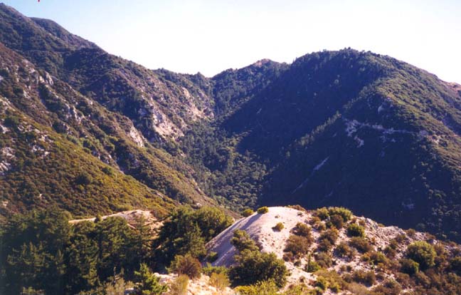
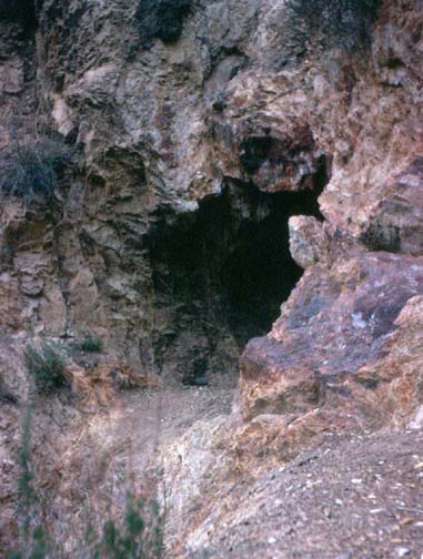
| View up Grand Canyon from Tom Sloan/Brown Mountain ridge | Shaft of Dawn Mine |
To begin the off-trail part of the hike, climb down into the gully to the south of the ruins, between the campground and the road. This is the start of Grand Canyon and you willl travel down it (with one detour) all the way to Millard Canyon. Very shortly after the start you will encounter the only obstacles on this hike where some scrambling is required, specifically several places where it is necessary to descend quite steep earthen slopes. In all cases there are convenient roots to provide holds though you should be careful not to rely on these too much. I recommend sliding down slowly on your rear while utilizing the hand and footholds provided by the roots. However none of these slopes are more than about 20ft high. About 20min below the campground, a much more dramatic obstacle bars your way. From above all you can see is a narrow, vertical slot that the stream has cut through solid rock. Almost perfectly sliced, this slot is only about 3ft wide and, in entering it, the stream makes an intial vertical drop of about 15ft. However, it is clearly fruitless to attempt to climb down into the slot for about 20yds further on the slot suddenly opens up into a very large bowl whose dimensions and depth one cannot discern from upstream. Fortunately, there is a fairly simple way to negotiate this dramatic obstacle. From a point in the streambed just upstream of the slot, you should be able to detect a use-trail that climbs up to the left (south). Follow this. Above the gully the terrain is much flatter though, on your right, is the edge of the cliff forming the large bowl. The faint trail contours around this abyss for about 100yds until it reaches a sidewash where it is fairly obvious that you can now climb down again into the the bottom of the canyon. After the descent, you may choose to hike upstream to examine the bowl. Unfortunately it is filled with an accumulation of tree trunks and branches, debris that is not easy to penetrate.
From this point on, the descent of Grand Canyon is a straightforward and pleasant hike in a pretty, wooded canyon. About 1hr from the campground you encounter the remains of several stone cabins with quite a few artifacts scattered around. And, along the same stretch, you may be able to find the remains of an old airplane embedded in the streambed. As you approach the junction with Millard Canyon (34o13.75'N 118o7.77'W and elevation 3200ft), more ruins are encountered and just above and to the left of the trail you will see the first of the horizontal shafts of the Dawn Mine. Unlike some of the other shafts this one is safe to enter but only extends back about 10yds into the canyon wall.
From the mid-1890s to the 1950s many dreamers tried their luck extracting gold
from the Dawn Mine and there are many shafts in the canyon walls near
the junction of Grand and Millard Canyons. One miner built a trail from this
location up to the tracks of the Mount Lowe railway (some 410ft above) in
an effort to find an easier way to transport ore to the valley below. This
trail still exists and provides an alternate return route for this hike.
But it is easier to continue on down Millard Canyon on the fairly good trail
that frequent use maintains. It is a relatively easy hike downstream but
you must look out for the point where the trail leaves the stream and
ascends the left side of canyon in order to bypass Millard Falls
(34o13.16'N 118o8.47'W and
elevation 2190ft). The first few feet of this trail are
steep and it looks unpromising when viewed from the stream; but a short
distance above it turns into a good trail. If you miss this turn-off you
will arrive at the top of Millard Falls which are dangerous to negotiate
without proper safety equipment. For this hike you should backtrack and find
the trail described above. Once it climbs a hundred feet or so the trail
then contours along the left wall of Millard Canyon passing the Falls well
below. Shortly after turning left and leaving Millard Canyon the trail
joins the asphalt of the Sunset Ridge Road and a few hundred yards bring
you back to the trailhead and your vehicle
(34o12.88'N 118o8.72'W and
elevation 2100ft).
Last updated 7/30/99.
Christopher E. Brennen