ADVENTURE HIKES AND CANYONEERING
IN THE SAN GABRIELS
© Christopher Earls Brennen

|
|---|

|
Hike B8. Lower Fusier Canyon
- Hiking time: 2 hours
- Estimated hiking distance: 1.9 miles
- Elevation gain: 220 feet
- USGS Topo Maps: Condor Peak
- Difficulties: Two moderate rappels of about 70ft, some swimming
- Special equipment: Rappelling equipment with 180ft rope, two rappel rings, 20ft webbing and drybags
-
ACA Rating: 3A I

Characteristics
This pleasant, short canyoneering adventure descends the lower section of Fusier Canyon into the Big Tujunga and then returns to the road by hiking up the Big Tujunga to the road bridge just downstream of Big Tujunga Dam. It is a lovely shaded little canyon and well-suited for almost anytime in the year though it could be more challenging in swiftwater after winter rains. Even in the summer the shade and the cool pools make for a pleasant outing. The hike up the lovely Big Tujunga beside Mill Creek is also very pleasant. However there are times after winter rains when crossing Mill Creek could be very dangerous. Thus it would be wise to check out the state of Mill Creek from the bridge just downstream of the Big Tujunga Dam before embarking on this adventure.
At other times when Mill Creek is fordable, this is a good canyon for the beginner though there may be times when the pool at the bottom of the second rappel may be deep enough to require a swimming disconnect.
Note that this hike could be conveniently combined with a descent of the lower section of Mary Jane Canyon and thus make for a comfortable day of canyoneering.
Trailhead
The trailhead for this hike is the parking area at the southwest end of the bridge along Big Tujunga Canyon Road just downstream of Big Tujunga Dam. The coordinates are 34o17.02'N 118o11.87'W and the elevation is 2100ft. This is where you should leave the return vehicles. Then drive west on Big Tujunga Canyon Road for 0.85mi to one of either two small turnouts just west of where the road crosses Fusier Canyon and near mile marker 590. Park here at 34o17.03'N 118o12.52'W and an elevation of 2240ft.
Hike
From the parked vehicle(s) (34o17.03'N 118o12.52'W and an elevation of 2240ft), hike down the usetrail into the canyon bottom just upstream (north) of the road crossing embankment and proceed through the drainage tunnel under the road to the south side. The first rappel is just beyond the exit from the drainage tunnel. It descends a near vertical 70ft using a webbing anchor in the streambed around two small trees. Watch for loose rock on the descent.
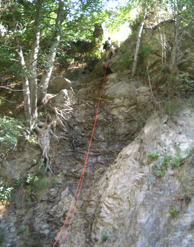 | 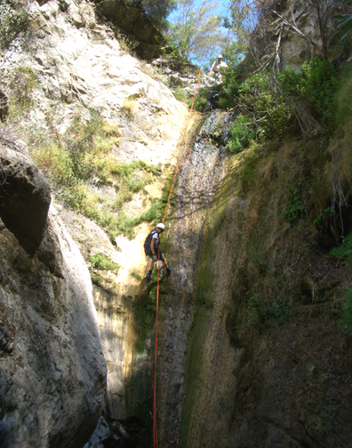
| |
|---|---|---|
| First rappel | Second rappel |
You descend into a verdant little canyon with lots of shade. The going is fairly easy for about 600yds after which, quite abruptly, you come to the top of the second rappel, a 60ft drop into a cliff-lined pothole with year-round water. You should reach this point about 1hr from the start. The anchor is a stout bush off to the right and you descend into the pool which is usually sandy-bottomed and 3-4ft deep. Another, deeper pool just around the corner usually requires swimming and there are other pools downstream that may aslo require swimming.
It is not far from the second rappel to the point where the canyon emerges
into the Big Tujunga at
34o16.73'N 118o12.55'W and
and elevation of 1940ft; here you should be about 1.5hr and
0.46mi from the start of the hike. At this confluence, the Big
Tujunga and Mill Creek make a lovely, shaded spot for a rest especially on a
hot summer day. Resuming your hike, turn upstream and follow the use trail
(usually found on the benches on either side of the river) for about
0.4mi and you will come to a large (optional) swimming hole and, just
beyond it, the beginning of the dirt roads built in this area during the
construction of Big Tujunga Dam. The dirt road starts at
34o16.73'N 118o12.19'W and
and elevation of 1980ft and climbs the left wall of the canyon to
meet the Big Tujunga Canyon Road just to the north of the road bridge.
This is where you should have left the return vehicle at
34o17.02'N 118o11.87'W and
an elevation of 2100ft. You should reach the end 1.35mi
and 2hrs from the start.
Last updated 7/30/06.
Christopher E. Brennen