ADVENTURE HIKES AND CANYONEERING
IN THE SAN GABRIELS
© Christopher Earls Brennen

|
|---|

|
Hike G1. East Fork of the San Gabriel
- Hiking time: 11 hours
- Estimated hiking distance: 16.5 miles
- Elevation loss: 4560 feet
- USGS Topo Maps: Mount San Antonio, Mt. Baldy, Glendora
- Difficulties: Much boulder scrambling
- Special equipment: Wading shoes, several pairs of socks
-
ACA Rating: 1B IV

Characteristics
The spectacular and storied East Fork of the San Gabriel River runs almost the whole way through the San Gabriel range. It starts just below the Vincent Saddle on the Angeles Crest Highway above the town of Wrightwood. From the saddle a trail descends Vincent Gulch into the magnificent Sheep Mountain Wilderness. This adventure is a very long one day hike or a good two day hike along the length of the East Fork. It traverses one of the wildest and most scenic areas in the San Gabriels. The scenery varies from the beautiful wooded section in the upper reaches of the canyon, magnificent in springtime, to the rugged and tortured grandeur of the East Fork Narrows midway through the journey. The hike is, however, a relatively easy one by adventure hike standards and involves no major obstacles though much wading and scrambling over rocks.
Trailheads
A very long car shuttle is required to set up a one-way trip. The upper terminus at Vincent Saddle is reached either by driving east along the Angeles Crest Highway over the 7901ft Dawson Saddle and down to Vincent Saddle at 34o22.40'N 117o45.15'W and an elevation of 6560ft. Alternatively, you can drive through Wrightwood and up the Angeles Crest Highway to Vincent Saddle. At the saddle there is an ample parking area. The lower end of the hike is the East Fork trailhead (34o14.21'N 117o45.92'W and elevation 2030ft), the same as described in the Allison Mine Loop.
Hike
The trail from Vincent Saddle (34o22.40'N 117o45.15'W, elevation 6560ft) down into Vincent Gulch drops quite steeply toward the Mine Gulch junction. This is rugged, forested country and, during the descent, you enter the Sheep Mountain Wilderness Area, the home of a substantial herd of bighorn sheep and a number of bears and cougars. The forest is a mix of conifers and deciduous trees whose autumn colors create spectacular scenery. The 9399ft Mount Baden-Powell forms a dramatic western wall to the canyon. After a descent of 2000ft over 4.4mi from Vincent Saddle (taking about 2hrs), you emerge onto a flat area of sand and rock at an elevation of about 4500ft. This is Mine Gulch junction (34o20.60'N 117o43.50'W, elevation 4480ft) where Vincent Gulch, Mine Gulch and Prairie Fork all meet before the sum of their contents plunges into the canyon of the East Fork of the San Gabriel River. Another trail drops down to this junction from the Cabin Flat campground on Prairie Fork.
 | 
| |
|---|---|---|
| Prairie Fork junction from Big Horn Mine | In East Fork Narrows |
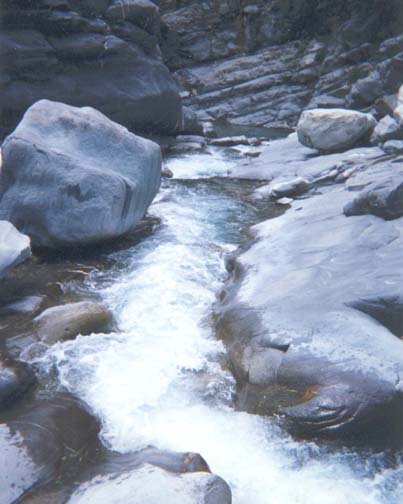
Shortly after leaving Mine Gulch junction and entering the East Fork canyon, the trail in the canyon bottom disappears, having been obliterated by the winter torrents that crash through this canyon. As you travel downstream the terrain becomes more rugged and precipitious. The mountains on both sides close in, forming a canyon with steep walls and a rock-strewn bottom. The river in the canyon is a substantial stream with alternating quiet sections interspersed with chaotic rapids. In many places you encounter small waterfalls and large boulders. It is not easy to keep track of your location for landmarks are rarely visible from the canyon bottom. Glimpses of the 8009ft Iron Mountain immediately to the east of the canyon do, however, allow you to make some estimates of your position.
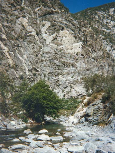
About 6hr 30min and some 9.5mi from Vincent Gap you reach the junction with Fish Fork (34o18.34'N 117o43.94'W, elevation 3330ft) that enters from the left or east. Fish Fork starts on the north slopes of Mount Baldy and flows west through a very rugged canyon to meet the East Fork at this junction. The combined waters enter an even deeper canyon that slices through the west slope of Iron Mountain. About a mile further south (and about 8hrs from the start), you encounter another substantial canyon junction where there are clear signs of human activity. This is the confluence with Iron Fork (34o17.73'N 117o44.47'W, elevation 3120ft) that enters from the west. Here you may identify the flattened area where goldminer George Trogden had his camp at the turn of the century. George was well known for his hospitality to all who passed this way. Occasionally things got out of hand as on Christmas night, 1917, when the gunslinging goldminer John Portwood shot and killed miner Herman Miller after a poker game.
 | 
| |
|---|---|---|
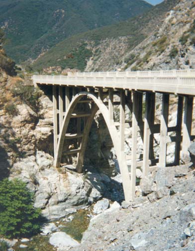
| Bridge to Nowhere | Swan Rock |
Earlier the East Fork of the San Gabriel river had been the site of a gold rush after the precious metal was discovered there in 1855. Below Iron Fork, the canyon is dotted with mines and the remnants of tailings. Even today several prospectors still live and work in the canyon while a number of weekend panners take out a few dollars worth of the gold for several hours work. There are a number of primitive campsites both above and below Iron Fork that provide suitable places for an overnight camp. There is also abundant driftwood available for a fire.
Below Iron Fork, there is a rudimentary trail in places, sometimes on one side of the river and sometimes on the other. This section between Iron Fork and the Bridge to Nowhere is called the Narrows. It is the deepest gorge in southern California, a place of grandeur with cascades and rockslides everywhere. While slow, the going is nevertheless straightforward with much boulder-scrambling but no real climbing. You must cross the river many times and this is more difficult early in the summer when the river is fuller. In several places, the trail climbs the west or right wall of the canyon in order to get around small waterfalls or long cascades. A little over 1hr beyond Iron Fork there are two such bypasses one after the other. Keep your eyes open for these trails. The second involves a sharp turn to the right and, as you make this turn, the Bridge to Nowhere suddenly appears before you at 34o16.99'N 117o44.81'W and an elevation of 2760ft.
The Bridge to Nowhere is one of the most bizarre artifacts to be found in the San Gabriel mountains. Back in the 1920s, Los Angeles County planned to build a highway all the way up the East Fork canyon to Mine Gulch Junction. From there the road would climb over Blue Ridge and drop down into Wrightwood. It would be among the most scenic roads in America. Construction began in 1929, most of the work being done by County prison work crews. By the mid-1930s the highway had reached the Narrows. There it was necessary to construct a concrete bridge high above the waters of the gorge. A tunnel was also chiselled out of sheer rock. However, the winter after this difficult construction task had been completed, an unprecedented storm arrived on March 1-2, 1938, depositing many inches of rain on the San Gabriel Mountains. The result was a tremendous flood that roared down the East Fork, obliterating everything in its path including more than five miles of the painstakingly constructed highway. Only the bridge was high enough above the waters to be virtually untouched. The futility of the project having been so emphatically demonstrated, the County abandoned their plans leaving a brand new concrete road bridge standing alone in the middle of the wilderness more than five miles from the nearest highway. It became a popular destination for hikers who dubbed it the ``Bridge to Nowhere''. Years later the County planned another highway up the East Fork. This time they intended to build it high up on the western wall to avoid a repetition of the earlier disaster. Begun in 1954, this second highway was abandoned in 1969 after only 4.5mi had been built. This second effort left substantial scars up on the western wall. Hopefully that will be the last time man will desecrate this wilderness and it will be left for future generations to enjoy in its nearly natural state.
It is important to find the trail that leads up to the Bridge to Nowhere because the Bridge, in turn, leads to a trail that bypasses a piece of private property in the canyon bottom (to say nothing of a particularly rugged stretch of canyon and one pool that you would have to swim). The trail south of the Bridge to Nowhere is frequently travelled and well-worn all the way to Heaton Flats and the East Fork trailhead. This last section can be covered in about 2hr 15min. Despite its popularity, the frequency with which the trail gets washed out means that it is rough in places. It crosses the East Fork 14 times between the Bridge and the trailhead.
A little under 1hr after leaving the Bridge to Nowhere, you will come to the junction where Allison Gulch flows into the East Fork (34o15.77'N 117o44.79'W, elevation 2410ft); at this point the route of the Allison Mine Loop joins the present itinerary. About 300yds further on, you pass a high cliff on your right composed of patches of white rock on a darker background. One of the white patches is shaped like a swan and hence the name Swan Rock. There are still 10 more river crossings to make downstream of Swan Rock. The last is just below Heaton Flats where goldminer William Heaton set up camp in 1891 and prospected until his death in 1924. A few hundred yards more and you come to the locked gate at the trailhead parking lot (34o14.21'N 117o45.92'W, elevation 2030ft).
The distance from Vincent Gap to the
trailhead is about 16.5mi and it takes about 11hr of travel
to complete the hike. It is possible to do it in a long and arduous
summer day but it is much more fun as a two day outing. Over two days
you have time to do some additional exploring, for example, into the canyons
of the Fish Fork or the Iron Fork.
Last updated 7/30/99.
Christopher E. Brennen