ADVENTURE HIKES AND CANYONEERING
IN THE SAN GABRIELS
© Christopher Earls Brennen

|
|---|

|
Hike C6. Cloudburst Canyon
- Hiking time: 3 hours
- Estimated hiking distance: 1.45 miles
- Elevation gain: 320 feet
- USGS Topo Maps: Chilao Flat
- Difficulties: Steep 250ft drop-in
- Special equipment: 160ft rope and rappelling gear
-
ACA Rating: 2A II

Characteristics
Cloudburst Canyon is one of a group of canyons that drop precipitously off the north face of Mount Disappointment just to the west of Red Box junction. They are readily visible from the Angeles Crest Highway just east of the Switzer Camp turnoff. From the road the bright cliffs seem unnegotiable but such a perspective telescopes the terrain.
Elsewhere we describe a challenging hike through the main canyon that we call Supercloud. Cloudburst is the only one named on the topograhical map and is, in fact, a modest canyon by comparison. It enters the complex from the southeast and, apart from a moderately difficult drop-in is an easy canyon suitable for a short adventure hike. The drop-in does require careful navigation since the route described is the only one that avoids the steep cliffs that prevent access from any other direction.
Trailhead
This hike requires a car shuttle. Drive both vehicles up the Angeles Crest Highway from La Canada/Flintridge past the junction at Clear Creek and the Switzer Parking Area. Two miles beyond the Switzer Camp turnoff, the road makes a broad sweeping turn to the left. At the start of this turn on the right side of the road there is a white metal gate where you will emerge at the conclusion of this hike. Turn one vehicle around and leave it in one of the turnouts just before the gate and bend (34o15.65'N 118o6.96'W and elevation 4010ft). Then, in the other vehicle, proceed on up the road to Red Box Junction and turn right onto the Mount Wilson road. A short distance (0.4mi) beyond Red Box, a gated asphalt road (2N52) switchbacks up to the right. Drive a few yards up this road to the parking area before the gate (34o15.26'N 118o6.08'W and elevation 4750ft).
Hike
From the parking area (34o15.26'N 118o6.08'W and elevation 4750ft) proceed around the metal gate and hike 0.7mi (20min) up the asphalt road (2N52) to the point where it reaches the first ridgetop and makes a hairpin turn to left. The ground drops away precipitously on three sides of the hairpin turn (34o15.35'N 118o6.64'W and elevation 5070ft). To the north you can see the busy Angeles Crest Highway as it climbs toward Red Box. On the south is the deep cut which Cloudburst Canyon slices into the mountainside. The off-trail route begins just beyond the hairpin where you make a steep descent into Cloudburst. Finding exactly the right gully is critical here for all other routes lead to the steep cliffs that otherwise completely surround the head of Cloudburst Canyon. The drop-in point is on the right side of the road just 60yds beyond the hairpin bend (and 20ft beyond the start of the guardrail on the left). Step over the guard rail on right and descend past a low retaining wall. The gully is very steep and earthy. After about 50ft, it is becomes steeper though still negotiable. For peace of mind we chose to rappel using the large pine tree on the left side to descend about 70ft. Then we anchored off a bush on the right to descend the next 80ft to where the inclination eased. From there it is simply a matter of descending the scree slope to the junction with the main branch of Cloudburst Canyon. You should reach this point (elevation 4830ft) about 1hr 20min from start.
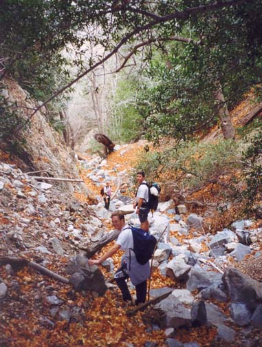
|
|---|
| Cloudburst Canyon |
The remainder of the hike is quite straightforward. Cloudburst Canyon
itself is rocky but easy going with little brush and no significant
downclimbs. It is normally dry. Since it runs almost due west, the left
or north side has trees and ferns while the south has the typical
desert like vegetation.
At 34o15.46'N 118o7.00'W, an
elevation of 4180ft and 2hrs from start you will
arrive at the junction
with a larger canyon entering on the left (Supercloud Canyon) and,
a short way below the canyon junction you will encounter two
debris dams with stream center drops of about 12ft and 6ft.
These can be negotiated on the left or rappelled if you wish.
About 50yds below the dams a broad trail (fire road) crosses the
streambed. Continue on down the stream bed and about 100yds further
at 34o15.59'N 118o7.07'W and
an elevation of 3990ft)
you encounter the fireroad again as it switches back. Go right along
the trail. This takes you back to the Angeles Crest Highway at the place
where you parked the first car
(34o15.65'N 118o6.96'W and
elevation 4010ft).
Last updated 1/1/00.
Christopher E. Brennen