ADVENTURE HIKES AND CANYONEERING
IN THE SAN GABRIELS
© Christopher Earls Brennen

|
|---|

|
Hike D3. Alpine Canyon and Chapman Falls
- Hiking time: 5 hours
- Estimated hiking distance: 6.5 miles
- Elevation gain: 1400 feet
- USGS Topo Maps: Mount Wilson
- Difficulties: 4 rappels, one of 250ft
- Special equipment: 250ft rope, 250ft pull cord, 20ft webbing, rappelling gear with 4 rappel rings
-
ACA Rating: 3A II

Characteristics
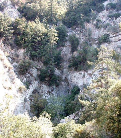
The adventure described here descends the short canyon leading to and including Chapman Falls (sometimes also called Alpine Falls), a tourist attraction during the heyday of the Mount Lowe Mountain Railway and the Mount Lowe Tavern. A trail from the Tavern led just a short distance down Grand Canyon to Chapman Falls which is at the end of a steep tributary that drops precipitiously down the south face of Mount Lowe. It is a short canyon with three other shorter rappels before you come to the 240ft Chapman Falls. Because of the small catch basin the water only runs occasionally and the canyon and falls are likely to be completely dry for most of the summer. The hike is probably best during the spring, fall or winter though the shade also eases the heat in the summer.
Trailhead
This canyon is most easily accessed from Eaton Saddle on the Mount Wilson Road. Drive north from La Canada/Flintridge on the Angeles Crest Highway to Red Box Junction where you turn right onto the Mount Wilson Road and proceed 2.3mi to the overlook at Eaton Saddle (34o14.36'N 118o5.60'W and elevation 5090ft). Park here in the broad dirt area near the metal gate across the fire road.
 | 
| |
|---|---|---|
| Chapman Falls from Mount Lowe Fire Road | Descending the 250ft Chapman Falls | |
(Photos by Gabe Sabloff) | ||
Hike
Once you pass the metal gate across the Mount Lowe fire road (34o14.36'N 118o5.60'W and elevation 5090ft) you are immediately rewarded by a spectacular view down into the cliff-ringed amphitheater that is the head of Eaton Canyon. Take a moment to enjoy these fabulous surroundings before proceeding up the fire road and through the tunnel, gaining elevation as you approach Markham Saddle and its watertank (elevation 5260ft). Continue along the gently descending fireroad as it rounds the end of the ridge and then descends eastwards toward the Mount Lowe junction. However, before you reach that junction you will be contouring around the head of Alpine Canyon and at that head you will encounter the Tom Sloane trail (with marker) forking off the road to the right at 34o13.71'N 118o6.61'W, an elevation of 4680ft, and 1hr and 2.7mi from the start.
Leave the road and proceed down the Tom Sloane trail for about 50yds to where a small gully descends steeply down to the left. Follow this down to the bottom of Alpine Canyon at 4540ft. Once in the canyon bottom it is only about 100yds to the top of the first rappel (elevation 4450ft) which you should reach about 1.5hrs from the start. This first rappel is a sloping 30ft drop from a bush anchor on the left. It is then a very short way to the second rappel at 4350ft, that consists of a 50ft rappel from a tree anchor on the left. Just a few steps bring you to 4300ft and the third rappel, a 40ft two-step rappel from bushes on right near the lip (it is possible to bypass this drop on the left). You should reach this point 2hr 10min from the morning start.
Downstream of this third rappel there are a couple of small dryfalls that are readily bypassed before you approach the top of the 250ft Chapman Falls, the highlight of this adventure, at an elevation of 4270ft. Several small precursor steps preceed the main drop of Chapman Falls and thus prevent a view of the vertical drop that comprises most of the descent. The drop requires a 250ft rope and a similar pull cord. After the precursor steps it is a vertical drop with a few steps, a large one near the bottom. The best anchor is a stout tree on the left at the top of one of the precursor steps. You should use enough webbing (about 12ft) so that the quicklink or rappel ring is beyond the lip of that step and thereby ease the rope recovery. Also use a vigorous rope toss so as to minimize possible hang-ups with bushes on the way down. You should reach the bottom of Chapman Falls at 4030ft about 3hrs after the morning start. It is a quiet and cool place for a break or lunch.
From the bottom of Chapman Falls it is just 50yds to the junction
of Alpine Canyon with Grand Canyon at
34o13.56'N 118o6.85'W, and elevation of
4030ft and 3.0mi and 3hrs from the morning start.
You may choose to go up Grand Canyon to
explore the slot canyon drop that represents the only technical hurdle
in the descent of the Grand Canyon described elsewhere in this collection
(that hurdle can also be bypassed). But following the present route you
should turn right at the junction and proceed down Grand Canyon for about
50yds to where you can discern a shallow gully and climbable slope
on the left. Climb straight up this wooded slope for
about 230ft to the Mount Lowe Fire Road at
34o13.50'N 118o6.91'W,
and an elevation of 4260ft. At the road turn left and hike up the
fireroad (the route of the old Mount Lowe railway) to the
hairpin bend with the turn off to Mount Lowe Campground (on the
left) at
34o13.58'N 118o6.60'W,
4450ft and 3.5mi from the start. At this hairpin leave the
road and follow the signed Mount Lowe trail up to where it again
joins the fire road. Turn left and follow the fireroad all the way back to
Eaton Saddle, passing the Tom Sloan trail junction on the way.
It is about a two hour hike from the bottom of Chapman Falls back to Eaton
Saddle (34o14.36'N 118o5.60'W and
elevation 5090ft), so the total hike duration should be about
5hrs during which you travel about 6.5mi.
Last updated 13/17/07.
Christopher E. Brennen